|
|
|||||||||||||||||
| Point ID: 9139 | Downloads | Plots | Site Data | Code: 15266300 |
|
|
|||||||||||||||||
| Download | |
|---|---|
| Site Descriptor Information | Site Time Series Data |
| Link to all available data | |
| View: | Time Series | All |
| Units: | m3/s |
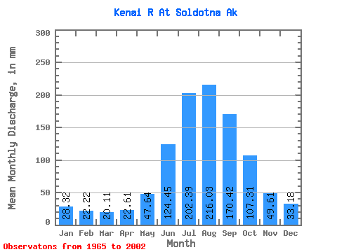
| Statistic | Jan | Feb | Mar | Apr | May | Jun | Jul | Aug | Sep | Oct | Nov | Dec | Annual |
|---|---|---|---|---|---|---|---|---|---|---|---|---|---|
| Mean | 28.32 | 22.42 | 20.11 | 22.61 | 47.63 | 124.45 | 202.36 | 216.00 | 170.42 | 107.30 | 49.61 | 33.18 | 1043.66 |
| Standard Deviation | 12.25 | 11.35 | 6.73 | 6.59 | 15.00 | 30.51 | 30.05 | 46.56 | 59.57 | 44.73 | 18.96 | 14.24 | 182.62 |
| Min | 12.34 | 11.24 | 12.01 | 11.79 | 29.26 | 71.75 | 145.51 | 130.66 | 85.30 | 42.80 | 23.69 | 16.99 | 670.57 |
| Max | 64.38 | 62.56 | 40.46 | 41.19 | 84.72 | 182.58 | 281.17 | 373.53 | 309.14 | 215.72 | 106.54 | 82.08 | 1455.16 |
| Coefficient of Variation | 0.43 | 0.51 | 0.34 | 0.29 | 0.32 | 0.24 | 0.15 | 0.22 | 0.35 | 0.42 | 0.38 | 0.43 | 0.17 |
 Return to R-Arctic Net Home Page