|
|
|||||||||||||||||
| Point ID: 9139 | Downloads | Plots | Site Data | Code: 15266300 |
|
|
|||||||||||||||||
| Download | |
|---|---|
| Site Descriptor Information | Site Time Series Data |
| Link to all available data | |
| View: | Time Series | All |
| Units: | mm |
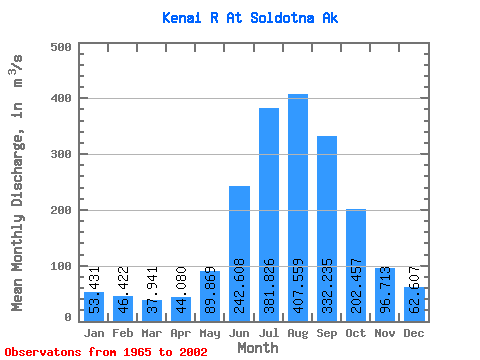
| Statistic | Jan | Feb | Mar | Apr | May | Jun | Jul | Aug | Sep | Oct | Nov | Dec | Annual |
|---|---|---|---|---|---|---|---|---|---|---|---|---|---|
| Mean | 53.43 | 46.42 | 37.94 | 44.08 | 89.87 | 242.61 | 381.83 | 407.56 | 332.24 | 202.46 | 96.71 | 62.61 | 167.10 |
| Standard Deviation | 23.11 | 23.51 | 12.69 | 12.85 | 28.31 | 59.48 | 56.69 | 87.86 | 116.13 | 84.41 | 36.96 | 26.87 | 29.24 |
| Min | 23.29 | 23.29 | 22.65 | 22.98 | 55.22 | 139.88 | 274.56 | 246.54 | 166.29 | 80.76 | 46.17 | 32.06 | 107.36 |
| Max | 121.47 | 129.55 | 76.34 | 80.31 | 159.85 | 355.94 | 530.53 | 704.82 | 602.68 | 407.04 | 207.69 | 154.87 | 232.99 |
| Coefficient of Variation | 0.43 | 0.51 | 0.34 | 0.29 | 0.32 | 0.24 | 0.15 | 0.22 | 0.35 | 0.42 | 0.38 | 0.43 | 0.17 |
 Return to R-Arctic Net Home Page