|
|
|||||||||||||||||
| Point ID: 9139 | Downloads | Plots | Site Data | Code: 15266300 |
|
|
|||||||||||||||||
| Download | |
|---|---|
| Site Descriptor Information | Site Time Series Data |
| Link to all available data | |
|
|
| View: | Statistics | Time Series |
| Units: | m3/s |
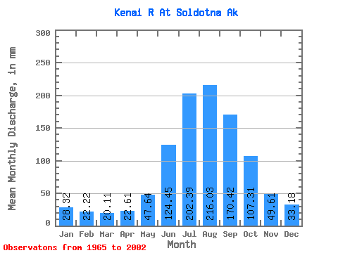
| Statistic | Jan | Feb | Mar | Apr | May | Jun | Jul | Aug | Sep | Oct | Nov | Dec | Annual |
|---|---|---|---|---|---|---|---|---|---|---|---|---|---|
| Mean | 28.32 | 22.42 | 20.11 | 22.61 | 47.63 | 124.45 | 202.36 | 216.00 | 170.42 | 107.30 | 49.61 | 33.18 | 1043.66 |
| Standard Deviation | 12.25 | 11.35 | 6.73 | 6.59 | 15.00 | 30.51 | 30.05 | 46.56 | 59.57 | 44.73 | 18.96 | 14.24 | 182.62 |
| Min | 12.34 | 11.24 | 12.01 | 11.79 | 29.26 | 71.75 | 145.51 | 130.66 | 85.30 | 42.80 | 23.69 | 16.99 | 670.57 |
| Max | 64.38 | 62.56 | 40.46 | 41.19 | 84.72 | 182.58 | 281.17 | 373.53 | 309.14 | 215.72 | 106.54 | 82.08 | 1455.16 |
| Coefficient of Variation | 0.43 | 0.51 | 0.34 | 0.29 | 0.32 | 0.24 | 0.15 | 0.22 | 0.35 | 0.42 | 0.38 | 0.43 | 0.17 |
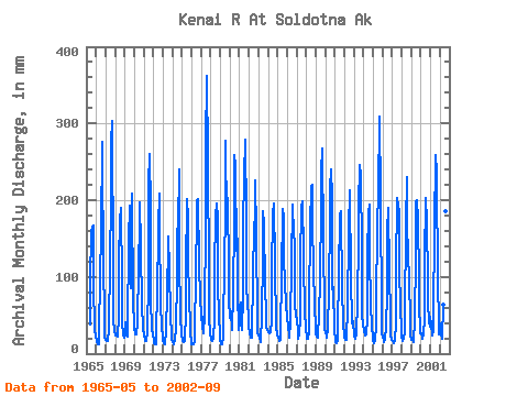
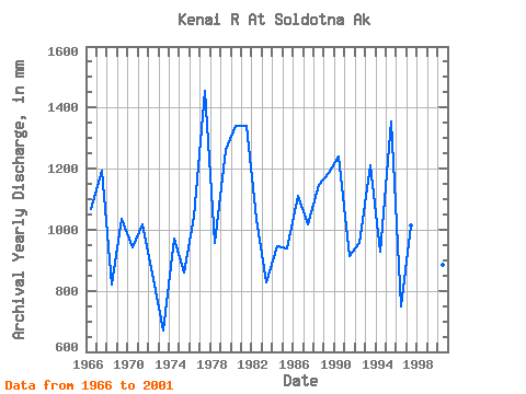
| Year | Jan | Feb | Mar | Apr | May | Jun | Jul | Aug | Sep | Oct | Nov | Dec | Annual | 1965 | 36.80 | 88.51 | 150.89 | 160.08 | 156.28 | 88.23 | 28.89 | 20.99 | 1966 | 16.79 | 12.75 | 11.89 | 11.63 | 27.92 | 91.80 | 152.81 | 265.43 | 232.20 | 119.48 | 37.62 | 21.67 | 997.42 | 1967 | 17.29 | 14.03 | 15.39 | 14.90 | 29.86 | 115.45 | 189.14 | 265.43 | 282.31 | 102.47 | 39.57 | 30.25 | 1112.16 | 1968 | 23.43 | 20.60 | 24.92 | 20.48 | 47.04 | 114.54 | 166.61 | 183.42 | 84.96 | 40.03 | 22.23 | 19.77 | 764.12 | 1969 | 39.77 | 30.82 | 22.34 | 20.13 | 31.10 | 138.41 | 185.98 | 121.84 | 79.54 | 201.15 | 61.05 | 39.58 | 966.99 | 1970 | 32.62 | 22.34 | 24.67 | 23.13 | 38.54 | 108.12 | 162.67 | 189.82 | 131.91 | 57.51 | 60.03 | 31.27 | 879.49 | 1971 | 24.56 | 15.94 | 16.07 | 15.58 | 27.45 | 91.56 | 213.25 | 251.26 | 177.47 | 67.27 | 31.45 | 22.80 | 949.36 | 1972 | 17.43 | 12.35 | 11.87 | 10.99 | 33.24 | 66.91 | 160.05 | 200.29 | 155.38 | 63.48 | 33.30 | 22.03 | 783.07 | 1973 | 16.75 | 12.16 | 11.78 | 13.51 | 27.29 | 73.92 | 135.68 | 147.42 | 102.21 | 49.03 | 22.09 | 16.66 | 625.29 | 1974 | 14.94 | 11.63 | 12.16 | 18.08 | 31.32 | 92.16 | 155.85 | 159.44 | 224.48 | 120.21 | 45.71 | 22.95 | 906.15 | 1975 | 18.46 | 14.62 | 14.63 | 14.73 | 52.49 | 99.57 | 193.52 | 169.96 | 109.37 | 78.07 | 24.55 | 15.85 | 800.84 | 1976 | 11.51 | 10.49 | 11.20 | 13.57 | 29.34 | 92.78 | 175.83 | 190.99 | 187.19 | 115.35 | 62.88 | 76.53 | 972.75 | 1977 | 41.82 | 42.07 | 34.64 | 24.80 | 48.93 | 159.19 | 262.18 | 348.31 | 235.35 | 96.18 | 44.51 | 24.20 | 1356.90 | 1978 | 18.53 | 15.48 | 16.16 | 18.79 | 41.53 | 102.29 | 171.67 | 188.38 | 163.89 | 90.27 | 43.99 | 26.81 | 893.90 | 1979 | 16.93 | 10.86 | 12.02 | 20.93 | 44.52 | 99.39 | 189.62 | 267.64 | 161.61 | 195.73 | 99.34 | 67.73 | 1178.53 | 1980 | 45.48 | 48.29 | 29.99 | 38.41 | 65.50 | 170.25 | 248.82 | 235.32 | 124.86 | 144.25 | 73.74 | 29.39 | 1249.72 | 1981 | 60.03 | 58.33 | 37.73 | 29.34 | 71.27 | 153.88 | 222.82 | 269.22 | 164.84 | 79.53 | 65.76 | 41.10 | 1250.43 | 1982 | 33.77 | 24.95 | 20.68 | 19.46 | 29.28 | 89.13 | 164.86 | 163.55 | 209.94 | 153.04 | 35.70 | 25.78 | 966.67 | 1983 | 23.40 | 17.69 | 14.76 | 19.97 | 43.77 | 121.19 | 178.62 | 162.14 | 81.78 | 50.48 | 32.93 | 29.96 | 772.81 | 1984 | 27.18 | 23.70 | 25.11 | 25.50 | 41.73 | 100.19 | 175.28 | 188.15 | 112.01 | 109.70 | 34.58 | 22.72 | 881.12 | 1985 | 21.91 | 19.99 | 15.87 | 16.07 | 31.08 | 92.67 | 182.12 | 171.99 | 119.51 | 84.73 | 65.22 | 58.23 | 875.11 | 1986 | 47.77 | 29.05 | 25.57 | 19.92 | 40.61 | 110.70 | 187.34 | 187.38 | 144.47 | 138.84 | 59.80 | 49.42 | 1035.91 | 1987 | 40.28 | 27.62 | 18.62 | 22.76 | 43.98 | 111.55 | 184.13 | 191.17 | 120.59 | 111.28 | 53.82 | 29.06 | 950.45 | 1988 | 21.62 | 16.40 | 18.22 | 27.01 | 59.86 | 153.98 | 208.96 | 212.03 | 159.46 | 105.78 | 60.24 | 30.06 | 1068.99 | 1989 | 26.18 | 19.81 | 19.68 | 21.58 | 48.23 | 88.68 | 187.31 | 228.60 | 249.90 | 142.06 | 48.50 | 31.03 | 1106.84 | 1990 | 26.05 | 20.45 | 20.58 | 29.92 | 79.00 | 166.98 | 206.88 | 230.76 | 190.03 | 80.44 | 80.63 | 28.52 | 1156.64 | 1991 | 16.79 | 13.39 | 13.45 | 15.87 | 33.34 | 96.06 | 175.19 | 179.48 | 166.90 | 88.39 | 32.43 | 25.59 | 852.97 | 1992 | 21.13 | 16.31 | 16.79 | 23.21 | 53.47 | 150.67 | 205.75 | 203.63 | 93.21 | 39.91 | 33.61 | 40.84 | 893.80 | 1993 | 21.44 | 17.17 | 19.02 | 24.75 | 64.13 | 139.07 | 184.63 | 237.44 | 217.16 | 127.48 | 48.85 | 34.32 | 1130.77 | 1994 | 32.93 | 27.18 | 22.30 | 23.06 | 44.56 | 119.54 | 177.04 | 186.98 | 115.73 | 64.51 | 30.84 | 23.25 | 864.38 | 1995 | 16.31 | 12.07 | 15.94 | 34.52 | 78.58 | 139.56 | 218.94 | 200.43 | 288.27 | 195.18 | 44.40 | 25.14 | 1264.25 | 1996 | 21.44 | 14.64 | 14.25 | 18.06 | 32.78 | 76.18 | 154.38 | 182.58 | 99.95 | 46.28 | 23.63 | 17.61 | 697.70 | 1997 | 15.26 | 14.03 | 13.59 | 15.55 | 39.86 | 100.76 | 195.15 | 185.49 | 173.69 | 111.78 | 52.30 | 33.98 | 946.87 | 1998 | 20.90 | 14.80 | 17.97 | 26.84 | 47.71 | 156.77 | 221.33 | 159.85 | 122.82 | 90.72 | 43.04 | 24.60 | 943.18 | 1999 | 17.15 | 15.16 | 14.17 | 17.54 | 39.63 | 120.99 | 190.14 | 192.71 | 164.18 | 92.25 | 64.06 | 26.16 | 950.45 | 2000 | 25.55 | 20.00 | 18.28 | 23.85 | 44.81 | 112.33 | 195.42 | 166.60 | 85.73 | 64.03 | 39.28 | 34.06 | 825.50 | 2001 | 45.85 | 32.84 | 23.22 | 27.79 | 45.72 | 151.96 | 249.09 | 229.14 | 209.26 | 96.78 | 31.06 | 24.85 | 1163.45 | 2002 | 37.74 | 23.41 | 18.21 | 17.91 | 61.38 | 151.95 | 190.41 | 179.26 | 140.28 |
|---|
 Return to R-Arctic Net Home Page