|
|
|||||||||||||||||
| Point ID: 8909 | Downloads | Plots | Site Data | Code: 70572 |
|
|
|||||||||||||||||
| Download | |
|---|---|
| Site Descriptor Information | Site Time Series Data |
| Link to all available data | |
| View: | Time Series | All |
| Units: | m3/s |
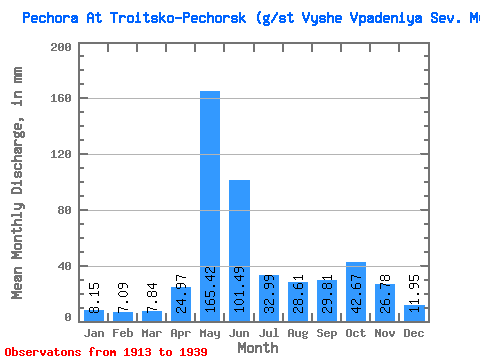
| Statistic | Jan | Feb | Mar | Apr | May | Jun | Jul | Aug | Sep | Oct | Nov | Dec | Annual |
|---|---|---|---|---|---|---|---|---|---|---|---|---|---|
| Mean | 8.15 | 7.15 | 7.84 | 24.97 | 165.40 | 101.49 | 32.98 | 28.61 | 29.81 | 42.66 | 26.78 | 11.95 | 484.80 |
| Standard Deviation | 1.25 | 1.14 | 1.41 | 26.24 | 38.38 | 45.21 | 15.81 | 19.41 | 15.63 | 16.87 | 12.12 | 3.20 | 97.78 |
| Min | 6.38 | 5.34 | 4.66 | 6.17 | 72.87 | 28.74 | 9.93 | 7.70 | 6.97 | 9.93 | 8.57 | 7.47 | 246.20 |
| Max | 10.93 | 9.96 | 10.93 | 104.91 | 224.99 | 239.80 | 66.31 | 84.71 | 64.01 | 74.88 | 46.73 | 20.86 | 654.03 |
| Coefficient of Variation | 0.15 | 0.16 | 0.18 | 1.05 | 0.23 | 0.45 | 0.48 | 0.68 | 0.53 | 0.40 | 0.45 | 0.27 | 0.20 |
 Return to R-Arctic Net Home Page