|
|
|||||||||||||||||
| Point ID: 8909 | Downloads | Plots | Site Data | Code: 70572 |
|
|
|||||||||||||||||
| Download | |
|---|---|
| Site Descriptor Information | Site Time Series Data |
| Link to all available data | |
| View: | Time Series | All |
| Units: | mm |
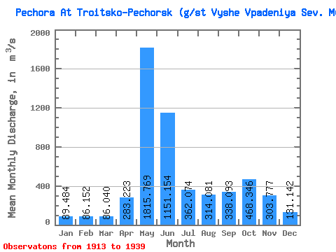
| Statistic | Jan | Feb | Mar | Apr | May | Jun | Jul | Aug | Sep | Oct | Nov | Dec | Annual |
|---|---|---|---|---|---|---|---|---|---|---|---|---|---|
| Mean | 89.48 | 86.15 | 86.04 | 283.22 | 1815.77 | 1151.15 | 362.07 | 314.08 | 338.09 | 468.35 | 303.78 | 131.14 | 451.62 |
| Standard Deviation | 13.66 | 13.74 | 15.45 | 297.59 | 421.37 | 512.78 | 173.56 | 213.13 | 177.34 | 185.24 | 137.45 | 35.13 | 91.09 |
| Min | 70.00 | 64.40 | 51.20 | 70.00 | 800.00 | 326.00 | 109.00 | 84.50 | 79.10 | 109.00 | 97.20 | 82.00 | 229.35 |
| Max | 120.00 | 120.00 | 120.00 | 1190.00 | 2470.00 | 2720.00 | 728.00 | 930.00 | 726.00 | 822.00 | 530.00 | 229.00 | 609.27 |
| Coefficient of Variation | 0.15 | 0.16 | 0.18 | 1.05 | 0.23 | 0.45 | 0.48 | 0.68 | 0.53 | 0.40 | 0.45 | 0.27 | 0.20 |
 Return to R-Arctic Net Home Page