|
|
|||||||||||||||||
| Point ID: 8909 | Downloads | Plots | Site Data | Code: 70572 |
|
|
|||||||||||||||||
| Download | |
|---|---|
| Site Descriptor Information | Site Time Series Data |
| Link to all available data | |
|
|
| View: | Statistics | Time Series |
| Units: | m3/s |
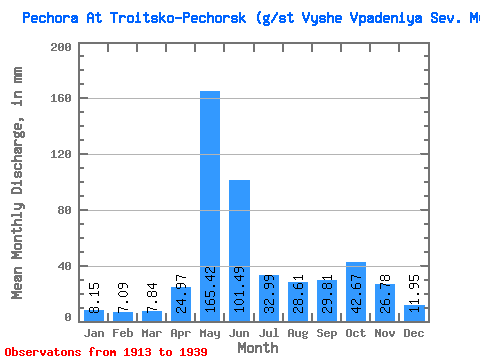
| Statistic | Jan | Feb | Mar | Apr | May | Jun | Jul | Aug | Sep | Oct | Nov | Dec | Annual |
|---|---|---|---|---|---|---|---|---|---|---|---|---|---|
| Mean | 8.15 | 7.15 | 7.84 | 24.97 | 165.40 | 101.49 | 32.98 | 28.61 | 29.81 | 42.66 | 26.78 | 11.95 | 484.80 |
| Standard Deviation | 1.25 | 1.14 | 1.41 | 26.24 | 38.38 | 45.21 | 15.81 | 19.41 | 15.63 | 16.87 | 12.12 | 3.20 | 97.78 |
| Min | 6.38 | 5.34 | 4.66 | 6.17 | 72.87 | 28.74 | 9.93 | 7.70 | 6.97 | 9.93 | 8.57 | 7.47 | 246.20 |
| Max | 10.93 | 9.96 | 10.93 | 104.91 | 224.99 | 239.80 | 66.31 | 84.71 | 64.01 | 74.88 | 46.73 | 20.86 | 654.03 |
| Coefficient of Variation | 0.15 | 0.16 | 0.18 | 1.05 | 0.23 | 0.45 | 0.48 | 0.68 | 0.53 | 0.40 | 0.45 | 0.27 | 0.20 |
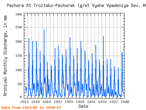
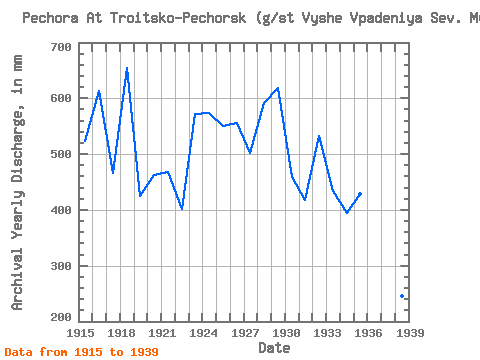
| Year | Jan | Feb | Mar | Apr | May | Jun | Jul | Aug | Sep | Oct | Nov | Dec | Annual | 1913 | 42.54 | 19.22 | 35.53 | 1914 | 8.64 | 217.70 | 105.80 | 37.16 | 31.15 | 33.94 | 30.70 | 8.99 | 7.92 | 1915 | 7.95 | 7.25 | 7.95 | 33.15 | 206.77 | 67.36 | 28.97 | 39.90 | 52.99 | 44.18 | 19.66 | 10.02 | 523.04 | 1916 | 9.75 | 8.88 | 9.75 | 10.14 | 206.77 | 147.23 | 22.23 | 42.81 | 41.08 | 63.58 | 41.88 | 12.39 | 614.11 | 1917 | 8.02 | 7.30 | 8.02 | 46.11 | 170.34 | 81.82 | 26.32 | 13.85 | 16.40 | 57.93 | 22.57 | 10.75 | 467.14 | 1918 | 8.78 | 8.00 | 8.78 | 8.64 | 72.87 | 239.80 | 53.92 | 60.21 | 64.01 | 74.88 | 39.59 | 14.03 | 654.03 | 1919 | 6.38 | 5.81 | 6.38 | 36.85 | 130.26 | 72.03 | 16.58 | 25.32 | 29.09 | 68.41 | 21.86 | 8.29 | 425.36 | 1920 | 8.29 | 7.55 | 8.29 | 104.91 | 120.24 | 82.52 | 40.99 | 32.70 | 21.86 | 19.86 | 8.57 | 8.20 | 463.49 | 1921 | 8.56 | 7.80 | 8.56 | 94.33 | 181.27 | 46.29 | 22.50 | 32.06 | 17.90 | 27.05 | 14.99 | 9.84 | 469.11 | 1922 | 6.65 | 6.06 | 6.65 | 8.71 | 189.46 | 92.57 | 26.96 | 20.40 | 12.52 | 16.67 | 9.61 | 7.47 | 401.10 | 1923 | 6.38 | 5.81 | 6.38 | 6.17 | 156.67 | 140.18 | 54.29 | 84.71 | 38.35 | 42.63 | 22.66 | 11.57 | 572.78 | 1924 | 7.92 | 7.22 | 7.92 | 68.50 | 175.80 | 69.30 | 66.31 | 30.33 | 33.68 | 50.55 | 43.91 | 14.39 | 573.23 | 1925 | 10.02 | 9.13 | 10.02 | 12.52 | 221.34 | 140.18 | 28.05 | 16.21 | 27.59 | 40.53 | 25.30 | 12.12 | 550.69 | 1926 | 7.92 | 7.22 | 7.92 | 10.05 | 153.94 | 125.19 | 45.45 | 56.66 | 48.84 | 52.28 | 21.95 | 20.86 | 555.70 | 1927 | 8.74 | 7.97 | 8.74 | 25.48 | 182.18 | 68.42 | 25.96 | 26.32 | 58.19 | 61.21 | 23.01 | 9.47 | 503.10 | 1928 | 10.93 | 9.96 | 10.93 | 10.58 | 206.77 | 149.88 | 46.27 | 20.04 | 19.40 | 51.56 | 42.41 | 15.21 | 591.48 | 1929 | 8.38 | 7.63 | 8.38 | 8.11 | 173.98 | 150.76 | 59.84 | 67.68 | 30.06 | 50.10 | 46.73 | 10.11 | 619.03 | 1930 | 6.38 | 5.81 | 6.38 | 6.17 | 138.45 | 117.26 | 50.46 | 29.88 | 26.27 | 37.53 | 24.95 | 11.57 | 459.09 | 1931 | 7.47 | 6.80 | 7.47 | 13.14 | 163.05 | 85.08 | 17.85 | 10.11 | 14.37 | 48.73 | 33.94 | 12.57 | 418.47 | 1932 | 8.80 | 7.33 | 7.36 | 25.83 | 193.11 | 83.58 | 49.46 | 11.48 | 32.09 | 62.94 | 38.97 | 14.66 | 532.59 | 1933 | 7.47 | 6.80 | 7.47 | 18.25 | 139.37 | 83.93 | 14.85 | 19.95 | 37.20 | 37.89 | 46.73 | 15.76 | 434.58 | 1934 | 9.56 | 7.76 | 9.47 | 10.84 | 224.99 | 43.20 | 9.93 | 7.71 | 6.97 | 23.23 | 32.62 | 11.39 | 394.35 | 1935 | 7.60 | 6.56 | 8.07 | 11.64 | 142.10 | 105.80 | 20.13 | 18.86 | 17.81 | 45.00 | 30.15 | 17.12 | 429.12 | 1936 | 9.47 | 6.97 | 7.97 | 21.16 | 141.19 | 73.44 | 10.75 | 7.70 | 12.78 | 28.97 | 31.03 | 15.03 | 365.07 | 1937 | 9.02 | 6.11 | 5.83 | 18.78 | 114.77 | 85.87 | 22.95 | 10.38 | 15.08 | 23.32 | 14.46 | 8.99 | 334.50 | 1938 | 6.67 | 5.34 | 4.66 | 20.63 | 110.22 | 28.74 | 20.13 | 10.20 | 8.76 | 9.93 | 12.26 | 10.29 | 246.20 | 1939 | 6.67 | 5.67 | 6.58 | 9.87 | 166.69 | 152.52 | 29.60 | 26.60 | 52.02 | 39.53 | 17.54 | 10.57 | 522.57 |
|---|
 Return to R-Arctic Net Home Page