|
|
|||||||||||||||||
| Point ID: 8875 | Downloads | Plots | Site Data | Code: 70470 |
|
|
|||||||||||||||||
| Download | |
|---|---|
| Site Descriptor Information | Site Time Series Data |
| Link to all available data | |
| View: | Time Series | All |
| Units: | m3/s |
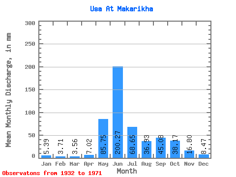
| Statistic | Jan | Feb | Mar | Apr | May | Jun | Jul | Aug | Sep | Oct | Nov | Dec | Annual |
|---|---|---|---|---|---|---|---|---|---|---|---|---|---|
| Mean | 5.39 | 3.75 | 3.56 | 7.02 | 85.74 | 200.27 | 68.64 | 36.92 | 45.08 | 38.16 | 16.80 | 8.47 | 516.54 |
| Standard Deviation | 1.88 | 1.45 | 1.45 | 10.08 | 60.92 | 70.23 | 27.00 | 14.76 | 19.68 | 17.01 | 9.30 | 2.98 | 82.84 |
| Min | 2.52 | 1.75 | 1.92 | 1.81 | 5.32 | 65.48 | 29.14 | 16.45 | 12.59 | 6.84 | 4.11 | 3.27 | 364.60 |
| Max | 10.89 | 8.43 | 8.17 | 60.05 | 230.57 | 359.55 | 142.11 | 81.66 | 95.70 | 91.27 | 56.57 | 14.77 | 711.08 |
| Coefficient of Variation | 0.35 | 0.39 | 0.41 | 1.44 | 0.71 | 0.35 | 0.39 | 0.40 | 0.44 | 0.45 | 0.55 | 0.35 | 0.16 |
 Return to R-Arctic Net Home Page