|
|
|||||||||||||||||
| Point ID: 8875 | Downloads | Plots | Site Data | Code: 70470 |
|
|
|||||||||||||||||
| Download | |
|---|---|
| Site Descriptor Information | Site Time Series Data |
| Link to all available data | |
|
|
| View: | Statistics | Time Series |
| Units: | m3/s |
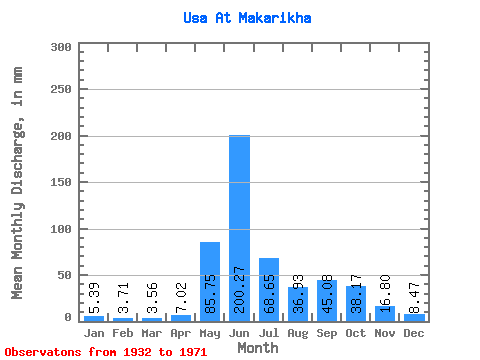
| Statistic | Jan | Feb | Mar | Apr | May | Jun | Jul | Aug | Sep | Oct | Nov | Dec | Annual |
|---|---|---|---|---|---|---|---|---|---|---|---|---|---|
| Mean | 5.39 | 3.75 | 3.56 | 7.02 | 85.74 | 200.27 | 68.64 | 36.92 | 45.08 | 38.16 | 16.80 | 8.47 | 516.54 |
| Standard Deviation | 1.88 | 1.45 | 1.45 | 10.08 | 60.92 | 70.23 | 27.00 | 14.76 | 19.68 | 17.01 | 9.30 | 2.98 | 82.84 |
| Min | 2.52 | 1.75 | 1.92 | 1.81 | 5.32 | 65.48 | 29.14 | 16.45 | 12.59 | 6.84 | 4.11 | 3.27 | 364.60 |
| Max | 10.89 | 8.43 | 8.17 | 60.05 | 230.57 | 359.55 | 142.11 | 81.66 | 95.70 | 91.27 | 56.57 | 14.77 | 711.08 |
| Coefficient of Variation | 0.35 | 0.39 | 0.41 | 1.44 | 0.71 | 0.35 | 0.39 | 0.40 | 0.44 | 0.45 | 0.55 | 0.35 | 0.16 |
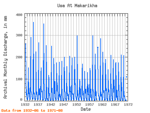
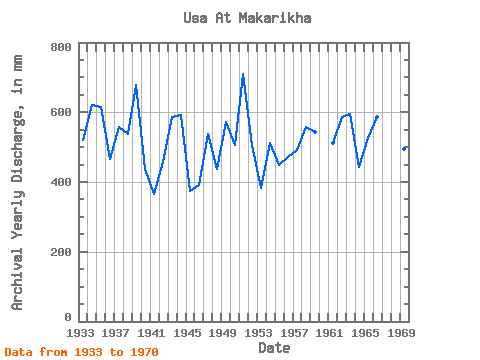
| Year | Jan | Feb | Mar | Apr | May | Jun | Jul | Aug | Sep | Oct | Nov | Dec | Annual | 1932 | 262.30 | 108.08 | 27.74 | 27.39 | 52.04 | 17.75 | 10.33 | 1933 | 7.41 | 4.89 | 4.92 | 6.32 | 25.78 | 151.88 | 142.11 | 33.30 | 56.57 | 49.64 | 24.72 | 14.77 | 521.20 | 1934 | 8.65 | 6.75 | 7.89 | 6.24 | 120.89 | 289.81 | 46.44 | 40.03 | 34.41 | 25.38 | 21.15 | 14.09 | 622.67 | 1935 | 10.89 | 8.43 | 8.17 | 7.44 | 19.25 | 359.55 | 71.65 | 38.35 | 29.91 | 37.95 | 12.94 | 8.73 | 616.42 | 1936 | 7.08 | 4.89 | 4.84 | 5.04 | 34.35 | 224.33 | 40.03 | 32.02 | 41.84 | 39.03 | 19.06 | 12.53 | 466.64 | 1937 | 7.81 | 5.65 | 5.56 | 5.66 | 13.61 | 265.40 | 75.66 | 26.70 | 29.91 | 50.04 | 56.57 | 12.77 | 557.57 | 1938 | 8.49 | 5.95 | 5.68 | 13.06 | 124.89 | 150.72 | 63.25 | 42.03 | 44.94 | 47.23 | 21.19 | 10.97 | 536.81 | 1939 | 6.88 | 4.74 | 3.92 | 3.20 | 18.41 | 351.80 | 86.86 | 81.66 | 74.00 | 22.06 | 13.60 | 8.77 | 678.67 | 1940 | 5.60 | 2.56 | 2.23 | 2.15 | 5.32 | 253.39 | 106.08 | 25.18 | 12.59 | 9.89 | 7.25 | 4.64 | 438.27 | 1941 | 2.52 | 1.75 | 1.92 | 1.81 | 120.09 | 98.41 | 43.63 | 24.58 | 34.02 | 22.62 | 9.38 | 5.60 | 364.60 | 1942 | 3.46 | 2.20 | 2.20 | 2.22 | 10.33 | 250.68 | 58.04 | 40.83 | 58.12 | 14.81 | 6.43 | 4.80 | 456.53 | 1943 | 3.82 | 2.78 | 2.89 | 4.42 | 201.35 | 139.09 | 42.43 | 35.07 | 38.16 | 91.27 | 19.80 | 10.49 | 587.79 | 1944 | 6.08 | 4.16 | 3.40 | 3.38 | 96.87 | 174.74 | 80.86 | 46.84 | 82.91 | 60.84 | 21.77 | 11.13 | 591.97 | 1945 | 6.37 | 4.23 | 3.80 | 3.85 | 55.24 | 177.45 | 29.14 | 17.93 | 19.88 | 31.26 | 14.72 | 9.37 | 374.00 | 1946 | 4.72 | 3.00 | 2.88 | 2.84 | 54.04 | 180.94 | 83.66 | 28.86 | 17.75 | 6.84 | 4.11 | 3.27 | 392.85 | 1947 | 3.65 | 2.55 | 2.60 | 5.00 | 110.08 | 200.31 | 73.66 | 45.63 | 42.62 | 34.55 | 12.36 | 6.21 | 538.27 | 1948 | 3.67 | 2.36 | 2.41 | 6.08 | 162.92 | 97.64 | 34.67 | 35.75 | 24.25 | 32.54 | 25.77 | 11.73 | 437.14 | 1949 | 7.25 | 5.07 | 4.52 | 4.88 | 56.04 | 204.18 | 95.27 | 42.83 | 50.37 | 64.45 | 24.56 | 12.93 | 571.84 | 1950 | 5.68 | 3.23 | 3.01 | 11.55 | 132.50 | 195.27 | 39.87 | 29.86 | 33.51 | 31.82 | 13.41 | 6.25 | 505.48 | 1951 | 5.80 | 4.23 | 3.96 | 60.05 | 87.67 | 199.53 | 90.87 | 76.06 | 81.36 | 66.05 | 21.85 | 14.17 | 711.08 | 1952 | 8.81 | 6.49 | 5.60 | 4.34 | 36.75 | 297.56 | 38.27 | 25.66 | 48.04 | 18.73 | 7.94 | 4.76 | 506.23 | 1953 | 3.87 | 3.13 | 2.81 | 24.91 | 101.68 | 85.62 | 42.83 | 18.65 | 55.02 | 26.42 | 10.77 | 7.53 | 382.42 | 1954 | 5.36 | 3.87 | 3.93 | 5.66 | 135.30 | 168.15 | 72.45 | 26.82 | 44.17 | 28.58 | 11.55 | 7.37 | 511.85 | 1955 | 4.40 | 3.18 | 2.87 | 18.29 | 140.50 | 65.48 | 40.83 | 36.91 | 53.85 | 55.64 | 21.43 | 8.53 | 449.30 | 1956 | 4.56 | 3.15 | 2.90 | 2.79 | 134.50 | 103.06 | 52.84 | 28.66 | 72.06 | 50.04 | 12.48 | 5.76 | 470.85 | 1957 | 4.60 | 3.60 | 2.89 | 2.77 | 153.31 | 129.41 | 59.65 | 17.33 | 54.24 | 39.03 | 17.94 | 8.45 | 491.38 | 1958 | 4.88 | 3.17 | 2.71 | 2.48 | 32.42 | 297.17 | 58.84 | 50.84 | 41.84 | 39.31 | 14.06 | 8.89 | 558.53 | 1959 | 4.60 | 3.43 | 2.93 | 2.73 | 118.09 | 214.26 | 73.25 | 24.42 | 44.56 | 38.11 | 11.39 | 7.17 | 544.38 | 1960 | 244.09 | 44.83 | 24.58 | 25.34 | 26.90 | 9.65 | 6.08 | 1961 | 4.12 | 2.99 | 3.16 | 3.30 | 35.79 | 284.38 | 60.45 | 23.78 | 22.47 | 33.10 | 27.74 | 8.45 | 511.89 | 1962 | 4.44 | 3.61 | 3.62 | 13.72 | 230.57 | 124.76 | 56.84 | 42.43 | 36.88 | 48.44 | 17.75 | 9.05 | 588.13 | 1963 | 6.08 | 4.34 | 3.45 | 3.24 | 158.92 | 189.46 | 50.84 | 48.44 | 57.73 | 53.24 | 13.33 | 8.21 | 595.57 | 1964 | 5.00 | 3.01 | 2.56 | 2.37 | 78.46 | 143.35 | 44.43 | 45.63 | 53.08 | 43.63 | 15.69 | 6.41 | 442.96 | 1965 | 3.41 | 2.15 | 2.50 | 2.75 | 40.43 | 208.83 | 101.68 | 58.44 | 53.47 | 36.91 | 11.28 | 5.40 | 527.01 | 1966 | 4.04 | 2.50 | 2.43 | 2.55 | 111.68 | 189.07 | 73.66 | 40.83 | 95.70 | 41.23 | 13.99 | 8.65 | 585.87 | 1967 | 4.80 | 3.37 | 3.54 | 8.21 | 174.13 | 175.12 | 57.24 | 16.45 | 16.47 | 50.84 | 35.57 | 9.37 | 553.15 | 1968 | 5.52 | 2.99 | 3.00 | 3.06 | 96.47 | 173.57 | 94.47 | 55.24 | 62.38 | 28.02 | 9.76 | 4.52 | 537.76 | 1969 | 3.07 | 2.45 | 2.36 | 2.61 | 6.61 | 210.00 | 126.89 | 46.44 | 62.77 | 17.69 | 7.83 | 5.40 | 494.72 | 1970 | 2.97 | 2.37 | 2.52 | 2.84 | 10.17 | 206.51 | 70.05 | 22.14 | 23.56 | 22.18 | 16.50 | 6.80 | 390.00 | 1971 | 4.32 | 3.12 | 2.73 | 2.88 | 12.61 | 273.54 | 112.88 | 52.04 |
|---|
 Return to R-Arctic Net Home Page