|
|
|||||||||||||||||
| Point ID: 8875 | Downloads | Plots | Site Data | Code: 70470 |
|
|
|||||||||||||||||
| Download | |
|---|---|
| Site Descriptor Information | Site Time Series Data |
| Link to all available data | |
| View: | Time Series | All |
| Units: | mm |
| Statistic | Jan | Feb | Mar | Apr | May | Jun | Jul | Aug | Sep | Oct | Nov | Dec | Annual |
|---|---|---|---|---|---|---|---|---|---|---|---|---|---|
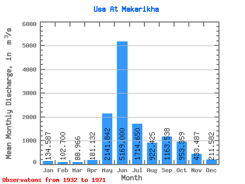
| Mean | 134.59 | 102.70 | 88.97 | 181.13 | 2141.84 | 5169.00 | 1714.65 | 922.42 | 1163.54 | 953.36 | 433.49 | 211.58 | 1094.94 |
| Standard Deviation | 46.87 | 39.70 | 36.15 | 260.09 | 1521.99 | 1812.75 | 674.40 | 368.60 | 507.99 | 424.92 | 240.17 | 74.49 | 175.60 |
| Min | 63.00 | 47.90 | 48.00 | 46.60 | 133.00 | 1690.00 | 728.00 | 411.00 | 325.00 | 171.00 | 106.00 | 81.70 | 772.88 |
| Max | 272.00 | 231.00 | 204.00 | 1550.00 | 5760.00 | 9280.00 | 3550.00 | 2040.00 | 2470.00 | 2280.00 | 1460.00 | 369.00 | 1507.33 |
| Coefficient of Variation | 0.35 | 0.39 | 0.41 | 1.44 | 0.71 | 0.35 | 0.39 | 0.40 | 0.44 | 0.45 | 0.55 | 0.35 | 0.16 |
 Return to R-Arctic Net Home Page