|
|
|||||||||||||||||
| Point ID: 8682 | Downloads | Plots | Site Data | Code: 11598 |
|
|
|||||||||||||||||
| Download | |
|---|---|
| Site Descriptor Information | Site Time Series Data |
| Link to all available data | |
| View: | Time Series | All |
| Units: | m3/s |
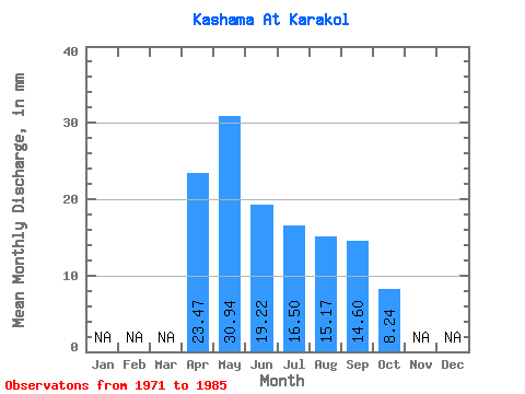
| Statistic | Jan | Feb | Mar | Apr | May | Jun | Jul | Aug | Sep | Oct | Nov | Dec | Annual |
|---|---|---|---|---|---|---|---|---|---|---|---|---|---|
| Mean | 23.47 | 30.93 | 19.21 | 16.50 | 15.16 | 14.60 | 8.24 | ||||||
| Standard Deviation | 15.31 | 11.33 | 11.43 | 11.69 | 13.06 | 12.70 | 4.26 | ||||||
| Min | 12.27 | 12.20 | 4.60 | 3.01 | 3.01 | 2.91 | 5.23 | ||||||
| Max | 50.31 | 46.91 | 43.87 | 37.24 | 43.58 | 39.57 | 11.25 | ||||||
| Coefficient of Variation | 0.65 | 0.37 | 0.59 | 0.71 | 0.86 | 0.87 | 0.52 |
 Return to R-Arctic Net Home Page