|
|
|||||||||||||||||
| Point ID: 8682 | Downloads | Plots | Site Data | Code: 11598 |
|
|
|||||||||||||||||
| Download | |
|---|---|
| Site Descriptor Information | Site Time Series Data |
| Link to all available data | |
| View: | Time Series | All |
| Units: | mm |
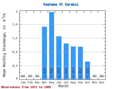
| Statistic | Jan | Feb | Mar | Apr | May | Jun | Jul | Aug | Sep | Oct | Nov | Dec | Annual |
|---|---|---|---|---|---|---|---|---|---|---|---|---|---|
| Mean | 1.53 | 1.95 | 1.25 | 1.04 | 0.96 | 0.95 | 0.52 | ||||||
| Standard Deviation | 1.00 | 0.71 | 0.74 | 0.74 | 0.82 | 0.83 | 0.27 | ||||||
| Min | 0.80 | 0.77 | 0.30 | 0.19 | 0.19 | 0.19 | 0.33 | ||||||
| Max | 3.28 | 2.96 | 2.86 | 2.35 | 2.75 | 2.58 | 0.71 | ||||||
| Coefficient of Variation | 0.65 | 0.37 | 0.59 | 0.71 | 0.86 | 0.87 | 0.52 |
 Return to R-Arctic Net Home Page