|
|
|||||||||||||||||
| Point ID: 8682 | Downloads | Plots | Site Data | Code: 11598 |
|
|
|||||||||||||||||
| Download | |
|---|---|
| Site Descriptor Information | Site Time Series Data |
| Link to all available data | |
|
|
| View: | Statistics | Time Series |
| Units: | m3/s |
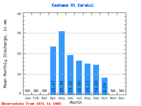
| Statistic | Jan | Feb | Mar | Apr | May | Jun | Jul | Aug | Sep | Oct | Nov | Dec | Annual |
|---|---|---|---|---|---|---|---|---|---|---|---|---|---|
| Mean | 23.47 | 30.93 | 19.21 | 16.50 | 15.16 | 14.60 | 8.24 | ||||||
| Standard Deviation | 15.31 | 11.33 | 11.43 | 11.69 | 13.06 | 12.70 | 4.26 | ||||||
| Min | 12.27 | 12.20 | 4.60 | 3.01 | 3.01 | 2.91 | 5.23 | ||||||
| Max | 50.31 | 46.91 | 43.87 | 37.24 | 43.58 | 39.57 | 11.25 | ||||||
| Coefficient of Variation | 0.65 | 0.37 | 0.59 | 0.71 | 0.86 | 0.87 | 0.52 |
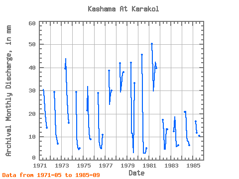
| Year | Jan | Feb | Mar | Apr | May | Jun | Jul | Aug | Sep | Oct | Nov | Dec | Annual | 1971 | 31.38 | 29.29 | 23.29 | 17.59 | 13.96 | 1972 | 30.43 | 18.86 | 11.73 | 9.35 | 7.05 | 1973 | 40.73 | 43.87 | 30.90 | 22.18 | 15.95 | 1974 | 30.27 | 9.51 | 5.55 | 4.59 | 5.06 | 1975 | 22.18 | 31.75 | 16.16 | 9.51 | 8.90 | 1976 | 29.79 | 8.44 | 6.81 | 5.23 | 4.91 | 11.25 | 1977 | 39.93 | 23.93 | 29.63 | 31.06 | 1978 | 43.26 | 29.45 | 33.75 | 38.82 | 38.04 | 1979 | 43.42 | 11.50 | 11.88 | 3.33 | 33.13 | 1980 | 46.91 | 12.27 | 3.01 | 3.01 | 2.91 | 5.23 | 1981 | 50.31 | 39.77 | 29.75 | 37.24 | 43.58 | 39.57 | 1982 | 17.33 | 12.84 | 4.60 | 4.75 | 13.95 | 13.19 | 1983 | 12.27 | 19.17 | 15.49 | 5.86 | 6.02 | 6.44 | 1984 | 20.86 | 21.71 | 9.97 | 8.56 | 8.40 | 6.29 | 1985 | 16.56 | 12.20 | 9.51 | 18.38 | 10.78 | 9.05 |
|---|
 Return to R-Arctic Net Home Page