|
|
|||||||||||||||||
| Point ID: 8680 | Downloads | Plots | Site Data | Code: 11596 |
|
|
|||||||||||||||||
| Download | |
|---|---|
| Site Descriptor Information | Site Time Series Data |
| Link to all available data | |
| View: | Time Series | All |
| Units: | m3/s |
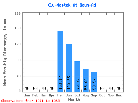
| Statistic | Jan | Feb | Mar | Apr | May | Jun | Jul | Aug | Sep | Oct | Nov | Dec | Annual |
|---|---|---|---|---|---|---|---|---|---|---|---|---|---|
| Mean | 153.15 | 120.85 | 76.77 | 57.97 | 50.54 | ||||||||
| Standard Deviation | 71.60 | 83.23 | 46.73 | 31.18 | 28.34 | ||||||||
| Min | 72.81 | 36.45 | 26.78 | 21.76 | 19.44 | ||||||||
| Max | 319.69 | 350.73 | 162.35 | 111.30 | 104.49 | ||||||||
| Coefficient of Variation | 0.47 | 0.69 | 0.61 | 0.54 | 0.56 |
 Return to R-Arctic Net Home Page