|
|
|||||||||||||||||
| Point ID: 8680 | Downloads | Plots | Site Data | Code: 11596 |
|
|
|||||||||||||||||
| Download | |
|---|---|
| Site Descriptor Information | Site Time Series Data |
| Link to all available data | |
|
|
| View: | Statistics | Time Series |
| Units: | m3/s |
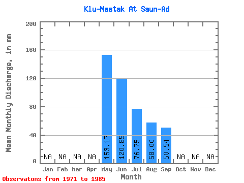
| Statistic | Jan | Feb | Mar | Apr | May | Jun | Jul | Aug | Sep | Oct | Nov | Dec | Annual |
|---|---|---|---|---|---|---|---|---|---|---|---|---|---|
| Mean | 153.15 | 120.85 | 76.77 | 57.97 | 50.54 | ||||||||
| Standard Deviation | 71.60 | 83.23 | 46.73 | 31.18 | 28.34 | ||||||||
| Min | 72.81 | 36.45 | 26.78 | 21.76 | 19.44 | ||||||||
| Max | 319.69 | 350.73 | 162.35 | 111.30 | 104.49 | ||||||||
| Coefficient of Variation | 0.47 | 0.69 | 0.61 | 0.54 | 0.56 |
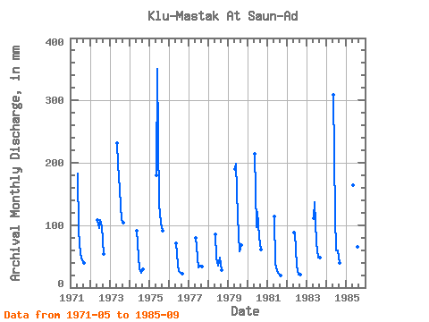
| Year | Jan | Feb | Mar | Apr | May | Jun | Jul | Aug | Sep | Oct | Nov | Dec | Annual | 1971 | 189.13 | 91.53 | 56.07 | 45.19 | 39.69 | 1972 | 112.14 | 94.77 | 112.14 | 102.10 | 53.46 | 1973 | 239.35 | 197.64 | 162.35 | 111.30 | 104.49 | 1974 | 93.73 | 70.47 | 30.13 | 25.11 | 29.97 | 1975 | 186.62 | 350.73 | 138.92 | 107.96 | 90.72 | 1976 | 72.81 | 36.45 | 26.78 | 24.27 | 22.68 | 1977 | 82.85 | 65.61 | 33.48 | 35.99 | 34.02 | 1978 | 88.71 | 48.60 | 36.82 | 50.21 | 28.35 | 1979 | 196.67 | 198.45 | 117.16 | 60.26 | 68.04 | 1980 | 221.77 | 97.20 | 125.53 | 83.69 | 60.75 | 1981 | 118.00 | 38.07 | 27.62 | 22.60 | 19.44 | 1982 | 91.22 | 88.29 | 35.99 | 21.76 | 21.06 | 1983 | 114.65 | 136.89 | 74.48 | 50.21 | 47.79 | 1984 | 319.69 | 114.21 | 61.93 | 61.09 | 39.69 | 1985 | 169.89 | 183.87 | 112.14 | 67.79 | 98.01 |
|---|
 Return to R-Arctic Net Home Page