|
|
|||||||||||||||||
| Point ID: 8680 | Downloads | Plots | Site Data | Code: 11596 |
|
|
|||||||||||||||||
| Download | |
|---|---|
| Site Descriptor Information | Site Time Series Data |
| Link to all available data | |
| View: | Time Series | All |
| Units: | mm |
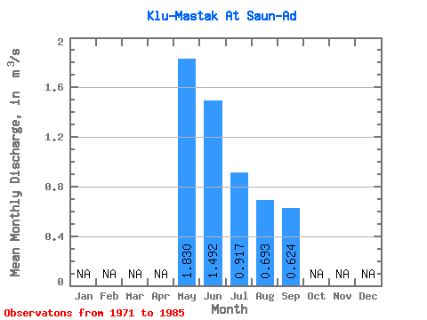
| Statistic | Jan | Feb | Mar | Apr | May | Jun | Jul | Aug | Sep | Oct | Nov | Dec | Annual |
|---|---|---|---|---|---|---|---|---|---|---|---|---|---|
| Mean | 1.83 | 1.49 | 0.92 | 0.69 | 0.62 | ||||||||
| Standard Deviation | 0.86 | 1.03 | 0.56 | 0.37 | 0.35 | ||||||||
| Min | 0.87 | 0.45 | 0.32 | 0.26 | 0.24 | ||||||||
| Max | 3.82 | 4.33 | 1.94 | 1.33 | 1.29 | ||||||||
| Coefficient of Variation | 0.47 | 0.69 | 0.61 | 0.54 | 0.56 |
 Return to R-Arctic Net Home Page