|
|
|||||||||||||||||
| Point ID: 8652 | Downloads | Plots | Site Data | Code: 11444 |
|
|
|||||||||||||||||
| Download | |
|---|---|
| Site Descriptor Information | Site Time Series Data |
| Link to all available data | |
| View: | Time Series | All |
| Units: | m3/s |
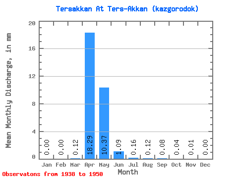
| Statistic | Jan | Feb | Mar | Apr | May | Jun | Jul | Aug | Sep | Oct | Nov | Dec | Annual |
|---|---|---|---|---|---|---|---|---|---|---|---|---|---|
| Mean | 0.00 | 0.00 | 0.12 | 18.30 | 10.37 | 1.09 | 0.16 | 0.12 | 0.08 | 0.04 | 0.01 | 0.01 | 30.40 |
| Standard Deviation | 0.00 | 0.00 | 0.35 | 14.33 | 12.49 | 1.16 | 0.11 | 0.10 | 0.07 | 0.05 | 0.03 | 0.01 | 25.59 |
| Min | 0.00 | 0.00 | 0.00 | 0.04 | 0.09 | 0.01 | 0.00 | 0.00 | 0.00 | 0.00 | 0.00 | 0.00 | 0.22 |
| Max | 0.01 | 0.00 | 1.16 | 37.68 | 42.66 | 3.50 | 0.30 | 0.25 | 0.19 | 0.15 | 0.10 | 0.05 | 75.90 |
| Coefficient of Variation | 3.11 | 1.45 | 2.99 | 0.78 | 1.20 | 1.06 | 0.68 | 0.77 | 0.80 | 1.08 | 2.22 | 3.03 | 0.84 |
 Return to R-Arctic Net Home Page