|
|
|||||||||||||||||
| Point ID: 8652 | Downloads | Plots | Site Data | Code: 11444 |
|
|
|||||||||||||||||
| Download | |
|---|---|
| Site Descriptor Information | Site Time Series Data |
| Link to all available data | |
| View: | Time Series | All |
| Units: | mm |
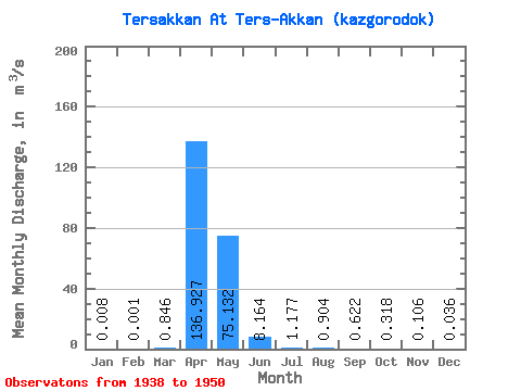
| Statistic | Jan | Feb | Mar | Apr | May | Jun | Jul | Aug | Sep | Oct | Nov | Dec | Annual |
|---|---|---|---|---|---|---|---|---|---|---|---|---|---|
| Mean | 0.01 | 0.00 | 0.85 | 136.93 | 75.13 | 8.16 | 1.18 | 0.90 | 0.62 | 0.32 | 0.11 | 0.04 | 18.69 |
| Standard Deviation | 0.02 | 0.00 | 2.53 | 107.23 | 90.49 | 8.66 | 0.81 | 0.69 | 0.50 | 0.34 | 0.23 | 0.11 | 15.73 |
| Min | 0.00 | 0.00 | 0.00 | 0.27 | 0.66 | 0.06 | 0.00 | 0.00 | 0.00 | 0.00 | 0.00 | 0.00 | 0.13 |
| Max | 0.08 | 0.00 | 8.43 | 282.00 | 309.00 | 26.20 | 2.17 | 1.84 | 1.39 | 1.10 | 0.77 | 0.36 | 46.66 |
| Coefficient of Variation | 3.11 | 1.45 | 2.99 | 0.78 | 1.20 | 1.06 | 0.68 | 0.77 | 0.80 | 1.08 | 2.22 | 3.03 | 0.84 |
 Return to R-Arctic Net Home Page