|
|
|||||||||||||||||
| Point ID: 8652 | Downloads | Plots | Site Data | Code: 11444 |
|
|
|||||||||||||||||
| Download | |
|---|---|
| Site Descriptor Information | Site Time Series Data |
| Link to all available data | |
|
|
| View: | Statistics | Time Series |
| Units: | m3/s |
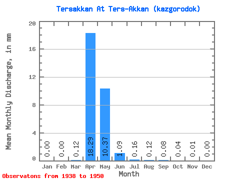
| Statistic | Jan | Feb | Mar | Apr | May | Jun | Jul | Aug | Sep | Oct | Nov | Dec | Annual |
|---|---|---|---|---|---|---|---|---|---|---|---|---|---|
| Mean | 0.00 | 0.00 | 0.12 | 18.30 | 10.37 | 1.09 | 0.16 | 0.12 | 0.08 | 0.04 | 0.01 | 0.01 | 30.40 |
| Standard Deviation | 0.00 | 0.00 | 0.35 | 14.33 | 12.49 | 1.16 | 0.11 | 0.10 | 0.07 | 0.05 | 0.03 | 0.01 | 25.59 |
| Min | 0.00 | 0.00 | 0.00 | 0.04 | 0.09 | 0.01 | 0.00 | 0.00 | 0.00 | 0.00 | 0.00 | 0.00 | 0.22 |
| Max | 0.01 | 0.00 | 1.16 | 37.68 | 42.66 | 3.50 | 0.30 | 0.25 | 0.19 | 0.15 | 0.10 | 0.05 | 75.90 |
| Coefficient of Variation | 3.11 | 1.45 | 2.99 | 0.78 | 1.20 | 1.06 | 0.68 | 0.77 | 0.80 | 1.08 | 2.22 | 3.03 | 0.84 |
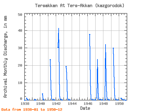
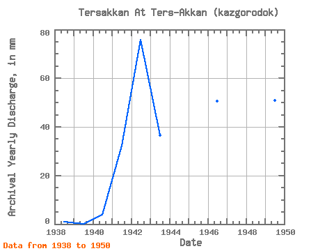
| Year | Jan | Feb | Mar | Apr | May | Jun | Jul | Aug | Sep | Oct | Nov | Dec | Annual | 1938 | 0.00 | 0.00 | 0.00 | 0.98 | 0.09 | 0.01 | 0.00 | 0.00 | 0.00 | 0.00 | 0.00 | 0.00 | 1.10 | 1939 | 0.00 | 0.00 | 0.00 | 0.04 | 0.16 | 0.02 | 0.00 | 0.00 | 0.00 | 0.00 | 0.00 | 0.00 | 0.22 | 1940 | 0.00 | 0.00 | 0.00 | 3.42 | 0.36 | 0.01 | 0.00 | 0.00 | 0.00 | 0.00 | 0.00 | 0.00 | 3.84 | 1941 | 0.00 | 0.00 | 0.00 | 23.25 | 7.73 | 0.78 | 0.20 | 0.12 | 0.07 | 0.03 | 0.00 | 0.00 | 32.39 | 1942 | 0.00 | 0.00 | 0.00 | 30.46 | 42.66 | 2.50 | 0.23 | 0.21 | 0.11 | 0.03 | 0.00 | 0.00 | 75.90 | 1943 | 0.00 | 0.00 | 0.00 | 19.24 | 15.46 | 1.43 | 0.17 | 0.18 | 0.13 | 0.06 | 0.00 | 0.00 | 36.68 | 1946 | 0.00 | 0.00 | 0.00 | 37.68 | 10.92 | 0.88 | 0.19 | 0.15 | 0.16 | 0.15 | 0.10 | 0.05 | 50.65 | 1947 | 0.01 | 0.00 | 1.16 | 23.38 | 5.15 | 0.47 | 0.27 | 0.25 | 0.19 | 0.10 | 0.01 | 0.00 | 31.22 | 1948 | 0.00 | 0.00 | 0.12 | 32.07 | 13.80 | 2.06 | 0.30 | 0.25 | 0.15 | 0.04 | 0.00 | 0.00 | 49.03 | 1949 | 0.00 | 0.00 | 0.00 | 29.80 | 16.98 | 3.50 | 0.26 | 0.07 | 0.06 | 0.06 | 0.04 | 0.00 | 50.94 | 1950 | 0.00 | 0.00 | 0.00 | 0.93 | 0.78 | 0.35 | 0.17 | 0.13 | 0.06 | 0.02 | 0.00 | 0.00 | 2.43 |
|---|
 Return to R-Arctic Net Home Page