|
|
|||||||||||||||||
| Point ID: 8602 | Downloads | Plots | Site Data | Code: 11209 |
|
|
|||||||||||||||||
| Download | |
|---|---|
| Site Descriptor Information | Site Time Series Data |
| Link to all available data | |
| View: | Time Series | All |
| Units: | m3/s |
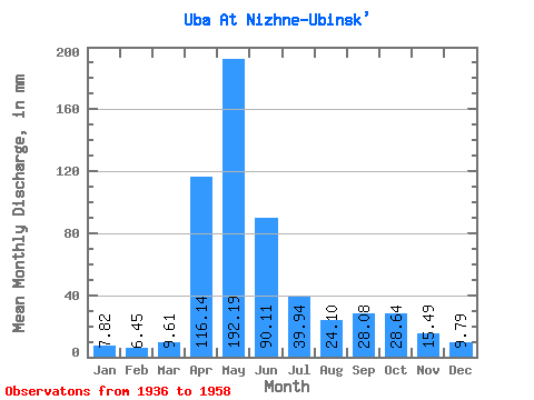
| Statistic | Jan | Feb | Mar | Apr | May | Jun | Jul | Aug | Sep | Oct | Nov | Dec | Annual |
|---|---|---|---|---|---|---|---|---|---|---|---|---|---|
| Mean | 7.82 | 6.50 | 9.60 | 116.14 | 192.16 | 90.11 | 39.93 | 24.09 | 28.08 | 28.64 | 15.49 | 9.79 | 571.15 |
| Standard Deviation | 2.65 | 2.18 | 4.68 | 48.09 | 50.75 | 52.64 | 21.96 | 17.95 | 25.48 | 16.72 | 6.20 | 3.32 | 139.66 |
| Min | 3.44 | 2.91 | 3.55 | 29.86 | 117.11 | 20.00 | 11.14 | 8.19 | 7.61 | 12.64 | 8.24 | 3.58 | 315.04 |
| Max | 13.65 | 11.14 | 22.22 | 193.41 | 283.91 | 272.15 | 93.63 | 73.98 | 131.05 | 79.71 | 31.44 | 15.37 | 879.43 |
| Coefficient of Variation | 0.34 | 0.34 | 0.49 | 0.41 | 0.26 | 0.58 | 0.55 | 0.74 | 0.91 | 0.58 | 0.40 | 0.34 | 0.24 |
 Return to R-Arctic Net Home Page