|
|
|||||||||||||||||
| Point ID: 8602 | Downloads | Plots | Site Data | Code: 11209 |
|
|
|||||||||||||||||
| Download | |
|---|---|
| Site Descriptor Information | Site Time Series Data |
| Link to all available data | |
|
|
| View: | Statistics | Time Series |
| Units: | m3/s |
| Statistic | Jan | Feb | Mar | Apr | May | Jun | Jul | Aug | Sep | Oct | Nov | Dec | Annual |
|---|---|---|---|---|---|---|---|---|---|---|---|---|---|
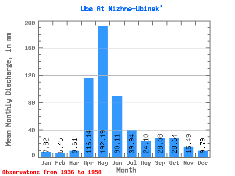
| Mean | 7.82 | 6.50 | 9.60 | 116.14 | 192.16 | 90.11 | 39.93 | 24.09 | 28.08 | 28.64 | 15.49 | 9.79 | 571.15 |
| Standard Deviation | 2.65 | 2.18 | 4.68 | 48.09 | 50.75 | 52.64 | 21.96 | 17.95 | 25.48 | 16.72 | 6.20 | 3.32 | 139.66 |
| Min | 3.44 | 2.91 | 3.55 | 29.86 | 117.11 | 20.00 | 11.14 | 8.19 | 7.61 | 12.64 | 8.24 | 3.58 | 315.04 |
| Max | 13.65 | 11.14 | 22.22 | 193.41 | 283.91 | 272.15 | 93.63 | 73.98 | 131.05 | 79.71 | 31.44 | 15.37 | 879.43 |
| Coefficient of Variation | 0.34 | 0.34 | 0.49 | 0.41 | 0.26 | 0.58 | 0.55 | 0.74 | 0.91 | 0.58 | 0.40 | 0.34 | 0.24 |
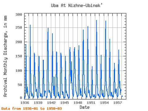
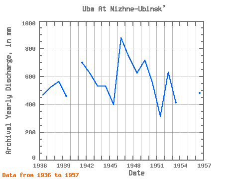
| Year | Jan | Feb | Mar | Apr | May | Jun | Jul | Aug | Sep | Oct | Nov | Dec | Annual | 1936 | 3.82 | 2.91 | 3.55 | 29.86 | 197.37 | 105.95 | 25.11 | 20.26 | 42.54 | 14.74 | 12.26 | 10.73 | 467.18 | 1937 | 6.66 | 4.35 | 4.15 | 33.03 | 267.53 | 107.01 | 37.40 | 12.47 | 10.67 | 20.17 | 14.14 | 11.74 | 525.62 | 1938 | 6.52 | 5.35 | 8.85 | 160.65 | 158.06 | 52.84 | 59.78 | 27.57 | 29.33 | 36.31 | 14.27 | 8.41 | 566.64 | 1939 | 6.44 | 4.45 | 7.12 | 150.34 | 151.78 | 43.07 | 33.03 | 11.36 | 9.54 | 20.80 | 15.88 | 8.27 | 461.36 | 1940 | 7.29 | 6.54 | 10.43 | 136.07 | 140.04 | 65.00 | 13.38 | 10.10 | 29.86 | 27.30 | 1941 | 7.89 | 5.47 | 12.67 | 193.41 | 255.79 | 87.46 | 30.57 | 23.04 | 30.65 | 26.51 | 19.31 | 9.25 | 700.74 | 1942 | 4.83 | 4.78 | 6.47 | 73.19 | 236.13 | 103.31 | 55.42 | 24.79 | 12.37 | 79.71 | 14.19 | 11.27 | 622.30 | 1943 | 6.12 | 5.27 | 6.93 | 165.14 | 165.98 | 91.42 | 25.66 | 11.52 | 11.97 | 24.49 | 11.41 | 6.55 | 532.54 | 1944 | 5.92 | 4.53 | 22.22 | 161.17 | 153.42 | 72.13 | 35.22 | 15.75 | 26.03 | 24.43 | 9.14 | 3.58 | 533.16 | 1945 | 5.43 | 4.65 | 4.67 | 149.81 | 117.93 | 22.96 | 30.85 | 19.41 | 11.07 | 17.61 | 11.39 | 5.11 | 400.50 | 1946 | 3.44 | 3.81 | 5.11 | 164.87 | 185.90 | 148.49 | 56.78 | 73.98 | 131.05 | 70.43 | 22.33 | 13.43 | 879.43 | 1947 | 13.65 | 9.05 | 18.18 | 160.65 | 186.45 | 118.64 | 93.63 | 58.15 | 31.18 | 21.98 | 21.27 | 9.31 | 740.50 | 1948 | 8.63 | 8.53 | 14.61 | 155.10 | 192.46 | 96.44 | 38.76 | 12.94 | 31.71 | 39.04 | 14.88 | 14.44 | 626.80 | 1949 | 12.72 | 8.90 | 9.69 | 160.38 | 249.78 | 101.20 | 70.98 | 21.18 | 36.99 | 21.59 | 15.30 | 12.59 | 719.46 | 1950 | 8.52 | 6.29 | 7.67 | 79.00 | 262.07 | 91.42 | 22.52 | 23.26 | 31.71 | 12.64 | 8.24 | 6.28 | 557.04 | 1951 | 6.77 | 5.95 | 7.02 | 93.27 | 117.11 | 20.00 | 11.14 | 8.19 | 7.61 | 16.02 | 14.19 | 8.46 | 315.04 | 1952 | 7.42 | 6.02 | 5.76 | 90.36 | 283.91 | 113.61 | 62.24 | 17.83 | 12.87 | 18.04 | 10.86 | 6.85 | 632.38 | 1953 | 7.15 | 6.42 | 8.65 | 91.68 | 158.33 | 48.09 | 19.68 | 15.10 | 10.28 | 32.21 | 10.52 | 7.62 | 414.12 | 1954 | 10.18 | 8.66 | 11.16 | 82.70 | 224.12 | 272.15 | 73.71 | 29.21 | 35.14 | 18.54 | 16.25 | 8.52 | 790.23 | 1955 | 11.63 | 11.14 | 13.76 | 75.83 | 216.21 | 31.18 | 13.79 | 10.35 | 23.83 | 20.88 | 8.90 | 13.62 | 448.65 | 1956 | 9.88 | 7.64 | 7.23 | 78.21 | 129.67 | 86.93 | 28.94 | 19.46 | 35.67 | 36.31 | 29.06 | 15.37 | 483.91 | 1957 | 8.35 | 9.05 | 14.88 | 70.28 | 177.44 | 103.05 | 39.86 | 64.15 | 15.77 | 30.30 | 31.44 | 14.22 | 576.48 | 1958 | 10.54 | 9.78 | 10.13 |
|---|
 Return to R-Arctic Net Home Page