|
|
|||||||||||||||||
| Point ID: 8602 | Downloads | Plots | Site Data | Code: 11209 |
|
|
|||||||||||||||||
| Download | |
|---|---|
| Site Descriptor Information | Site Time Series Data |
| Link to all available data | |
| View: | Time Series | All |
| Units: | mm |
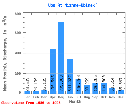
| Statistic | Jan | Feb | Mar | Apr | May | Jun | Jul | Aug | Sep | Oct | Nov | Dec | Annual |
|---|---|---|---|---|---|---|---|---|---|---|---|---|---|
| Mean | 28.64 | 26.14 | 35.18 | 439.55 | 703.91 | 341.03 | 146.27 | 88.26 | 106.29 | 104.91 | 58.61 | 35.87 | 177.53 |
| Standard Deviation | 9.70 | 8.78 | 17.15 | 181.99 | 185.91 | 199.23 | 80.44 | 65.76 | 96.42 | 61.24 | 23.45 | 12.15 | 43.41 |
| Min | 12.60 | 11.70 | 13.00 | 113.00 | 429.00 | 75.70 | 40.80 | 30.00 | 28.80 | 46.30 | 31.20 | 13.10 | 97.92 |
| Max | 50.00 | 44.80 | 81.40 | 732.00 | 1040.00 | 1030.00 | 343.00 | 271.00 | 496.00 | 292.00 | 119.00 | 56.30 | 273.36 |
| Coefficient of Variation | 0.34 | 0.34 | 0.49 | 0.41 | 0.26 | 0.58 | 0.55 | 0.74 | 0.91 | 0.58 | 0.40 | 0.34 | 0.24 |
 Return to R-Arctic Net Home Page