|
|
|||||||||||||||||
| Point ID: 8383 | Downloads | Plots | Site Data | Code: 9469 |
|
|
|||||||||||||||||
| Download | |
|---|---|
| Site Descriptor Information | Site Time Series Data |
| Link to all available data | |
| View: | Time Series | All |
| Units: | m3/s |
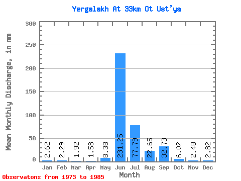
| Statistic | Jan | Feb | Mar | Apr | May | Jun | Jul | Aug | Sep | Oct | Nov | Dec | Annual |
|---|---|---|---|---|---|---|---|---|---|---|---|---|---|
| Mean | 2.62 | 2.30 | 1.91 | 1.57 | 8.38 | 231.24 | 77.78 | 22.66 | 32.72 | 6.03 | 2.48 | 2.82 | 393.58 |
| Standard Deviation | 4.86 | 4.24 | 3.85 | 3.43 | 11.47 | 66.62 | 58.88 | 28.44 | 22.03 | 8.37 | 5.52 | 5.37 | 129.66 |
| Min | 0.00 | 0.00 | 0.00 | 0.00 | 0.00 | 140.15 | 4.65 | 2.62 | 2.31 | 0.52 | 0.00 | 0.00 | 231.47 |
| Max | 13.38 | 11.39 | 11.34 | 9.29 | 35.47 | 334.91 | 194.53 | 84.03 | 66.14 | 23.55 | 16.32 | 13.09 | 631.37 |
| Coefficient of Variation | 1.86 | 1.84 | 2.01 | 2.18 | 1.37 | 0.29 | 0.76 | 1.25 | 0.67 | 1.39 | 2.23 | 1.90 | 0.33 |
 Return to R-Arctic Net Home Page