|
|
|||||||||||||||||
| Point ID: 8383 | Downloads | Plots | Site Data | Code: 9469 |
|
|
|||||||||||||||||
| Download | |
|---|---|
| Site Descriptor Information | Site Time Series Data |
| Link to all available data | |
|
|
| View: | Statistics | Time Series |
| Units: | m3/s |
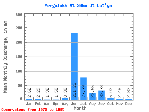
| Statistic | Jan | Feb | Mar | Apr | May | Jun | Jul | Aug | Sep | Oct | Nov | Dec | Annual |
|---|---|---|---|---|---|---|---|---|---|---|---|---|---|
| Mean | 2.62 | 2.30 | 1.91 | 1.57 | 8.38 | 231.24 | 77.78 | 22.66 | 32.72 | 6.03 | 2.48 | 2.82 | 393.58 |
| Standard Deviation | 4.86 | 4.24 | 3.85 | 3.43 | 11.47 | 66.62 | 58.88 | 28.44 | 22.03 | 8.37 | 5.52 | 5.37 | 129.66 |
| Min | 0.00 | 0.00 | 0.00 | 0.00 | 0.00 | 140.15 | 4.65 | 2.62 | 2.31 | 0.52 | 0.00 | 0.00 | 231.47 |
| Max | 13.38 | 11.39 | 11.34 | 9.29 | 35.47 | 334.91 | 194.53 | 84.03 | 66.14 | 23.55 | 16.32 | 13.09 | 631.37 |
| Coefficient of Variation | 1.86 | 1.84 | 2.01 | 2.18 | 1.37 | 0.29 | 0.76 | 1.25 | 0.67 | 1.39 | 2.23 | 1.90 | 0.33 |
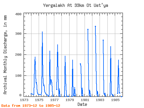
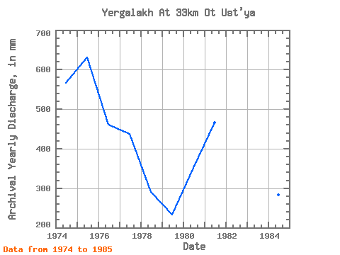
| Year | Jan | Feb | Mar | Apr | May | Jun | Jul | Aug | Sep | Oct | Nov | Dec | Annual | 1973 | 13.09 | 1974 | 13.38 | 11.39 | 11.34 | 9.29 | 9.89 | 140.15 | 194.53 | 66.59 | 66.14 | 22.97 | 11.82 | 11.34 | 567.12 | 1975 | 9.30 | 8.48 | 8.14 | 8.44 | 24.72 | 309.58 | 100.03 | 53.50 | 54.88 | 23.55 | 16.32 | 12.21 | 631.37 | 1976 | 8.72 | 7.68 | 3.49 | 1.10 | 6.98 | 216.99 | 56.70 | 84.03 | 63.32 | 9.30 | 1.46 | 0.00 | 461.49 | 1977 | 0.00 | 0.00 | 0.00 | 0.00 | 35.47 | 247.94 | 112.53 | 2.62 | 36.30 | 0.87 | 0.00 | 0.00 | 437.19 | 1978 | 0.00 | 0.00 | 0.00 | 0.00 | 0.99 | 192.50 | 79.67 | 12.21 | 2.31 | 0.99 | 0.11 | 0.00 | 289.96 | 1979 | 0.00 | 0.00 | 0.00 | 0.00 | 0.76 | 174.77 | 4.65 | 3.49 | 43.06 | 3.20 | 0.00 | 0.00 | 232.90 | 1980 | 0.00 | 0.00 | 0.00 | 0.00 | 0.00 | 155.91 | 148.00 | 4.36 | 40.53 | 3.20 | 0.00 | 0.00 | 352.09 | 1981 | 0.00 | 0.00 | 0.00 | 0.00 | 0.00 | 320.83 | 107.88 | 3.78 | 30.68 | 0.52 | 0.00 | 0.00 | 466.83 | 1982 | 0.00 | 0.00 | 0.00 | 0.00 | 0.00 | 334.91 | 79.09 | 8.43 | 25.61 | 1.92 | 0.00 | 0.00 | 453.64 | 1983 | 0.00 | 0.00 | 0.00 | 0.00 | 0.00 | 268.49 | 15.99 | 8.43 | 16.32 | 2.47 | 0.00 | 0.00 | 315.40 | 1984 | 0.00 | 0.00 | 0.00 | 0.00 | 6.69 | 239.22 | 15.99 | 6.98 | 9.57 | 2.01 | 0.00 | 0.00 | 283.53 | 1985 | 0.00 | 0.00 | 0.00 | 0.00 | 15.12 | 173.64 | 18.32 | 17.45 | 3.94 | 1.34 | 0.00 | 0.00 | 231.47 |
|---|
 Return to R-Arctic Net Home Page