|
|
|||||||||||||||||
| Point ID: 8383 | Downloads | Plots | Site Data | Code: 9469 |
|
|
|||||||||||||||||
| Download | |
|---|---|
| Site Descriptor Information | Site Time Series Data |
| Link to all available data | |
| View: | Time Series | All |
| Units: | mm |
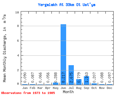
| Statistic | Jan | Feb | Mar | Apr | May | Jun | Jul | Aug | Sep | Oct | Nov | Dec | Annual |
|---|---|---|---|---|---|---|---|---|---|---|---|---|---|
| Mean | 0.09 | 0.09 | 0.07 | 0.06 | 0.29 | 8.22 | 2.67 | 0.78 | 1.16 | 0.21 | 0.09 | 0.10 | 1.15 |
| Standard Deviation | 0.17 | 0.16 | 0.13 | 0.12 | 0.39 | 2.37 | 2.02 | 0.98 | 0.78 | 0.29 | 0.20 | 0.18 | 0.38 |
| Min | 0.00 | 0.00 | 0.00 | 0.00 | 0.00 | 4.98 | 0.16 | 0.09 | 0.08 | 0.02 | 0.00 | 0.00 | 0.68 |
| Max | 0.46 | 0.43 | 0.39 | 0.33 | 1.22 | 11.90 | 6.69 | 2.89 | 2.35 | 0.81 | 0.58 | 0.45 | 1.84 |
| Coefficient of Variation | 1.86 | 1.84 | 2.01 | 2.18 | 1.37 | 0.29 | 0.76 | 1.25 | 0.67 | 1.39 | 2.23 | 1.90 | 0.33 |
 Return to R-Arctic Net Home Page