|
|
|||||||||||||||||
| Point ID: 8380 | Downloads | Plots | Site Data | Code: 9462 |
|
|
|||||||||||||||||
| Download | |
|---|---|
| Site Descriptor Information | Site Time Series Data |
| Link to all available data | |
| View: | Time Series | All |
| Units: | m3/s |
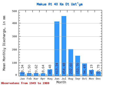
| Statistic | Jan | Feb | Mar | Apr | May | Jun | Jul | Aug | Sep | Oct | Nov | Dec | Annual |
|---|---|---|---|---|---|---|---|---|---|---|---|---|---|
| Mean | 28.34 | 21.66 | 20.64 | 18.62 | 49.47 | 413.36 | 454.40 | 202.60 | 153.70 | 94.45 | 45.19 | 33.79 | 1507.32 |
| Standard Deviation | 3.66 | 2.32 | 2.03 | 2.68 | 60.44 | 130.33 | 210.13 | 69.93 | 46.79 | 45.95 | 6.05 | 6.43 | 100.56 |
| Min | 22.70 | 18.91 | 17.51 | 13.81 | 14.91 | 251.67 | 149.79 | 85.59 | 111.09 | 52.52 | 35.77 | 25.94 | 1367.86 |
| Max | 32.42 | 24.81 | 23.34 | 21.34 | 182.86 | 621.95 | 784.60 | 308.00 | 255.43 | 180.26 | 53.97 | 45.39 | 1623.21 |
| Coefficient of Variation | 0.13 | 0.11 | 0.10 | 0.14 | 1.22 | 0.32 | 0.46 | 0.34 | 0.30 | 0.49 | 0.13 | 0.19 | 0.07 |
 Return to R-Arctic Net Home Page