|
|
|||||||||||||||||
| Point ID: 8380 | Downloads | Plots | Site Data | Code: 9462 |
|
|
|||||||||||||||||
| Download | |
|---|---|
| Site Descriptor Information | Site Time Series Data |
| Link to all available data | |
|
|
| View: | Statistics | Time Series |
| Units: | m3/s |
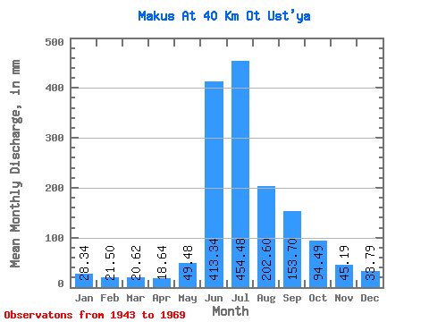
| Statistic | Jan | Feb | Mar | Apr | May | Jun | Jul | Aug | Sep | Oct | Nov | Dec | Annual |
|---|---|---|---|---|---|---|---|---|---|---|---|---|---|
| Mean | 28.34 | 21.66 | 20.64 | 18.62 | 49.47 | 413.36 | 454.40 | 202.60 | 153.70 | 94.45 | 45.19 | 33.79 | 1507.32 |
| Standard Deviation | 3.66 | 2.32 | 2.03 | 2.68 | 60.44 | 130.33 | 210.13 | 69.93 | 46.79 | 45.95 | 6.05 | 6.43 | 100.56 |
| Min | 22.70 | 18.91 | 17.51 | 13.81 | 14.91 | 251.67 | 149.79 | 85.59 | 111.09 | 52.52 | 35.77 | 25.94 | 1367.86 |
| Max | 32.42 | 24.81 | 23.34 | 21.34 | 182.86 | 621.95 | 784.60 | 308.00 | 255.43 | 180.26 | 53.97 | 45.39 | 1623.21 |
| Coefficient of Variation | 0.13 | 0.11 | 0.10 | 0.14 | 1.22 | 0.32 | 0.46 | 0.34 | 0.30 | 0.49 | 0.13 | 0.19 | 0.07 |
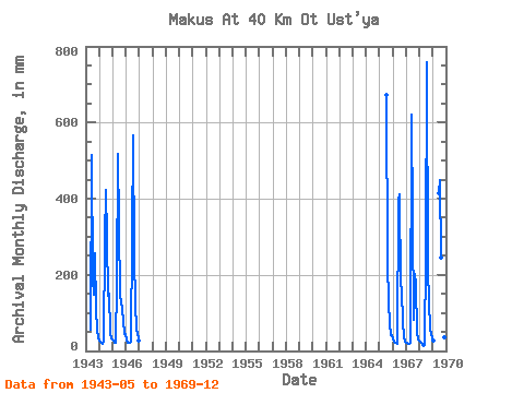
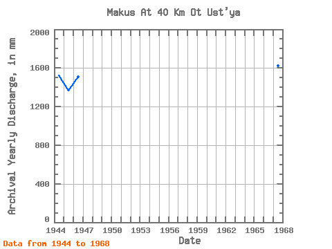
| Year | Jan | Feb | Mar | Apr | May | Jun | Jul | Aug | Sep | Oct | Nov | Dec | Annual | 1943 | 57.06 | 513.38 | 198.42 | 152.38 | 255.43 | 115.42 | 53.97 | 36.96 | 1944 | 29.18 | 22.45 | 20.75 | 18.83 | 25.29 | 289.95 | 438.34 | 308.00 | 144.98 | 154.32 | 46.44 | 33.72 | 1523.23 | 1945 | 32.42 | 24.81 | 20.75 | 20.08 | 182.86 | 517.14 | 149.79 | 134.87 | 111.09 | 82.35 | 45.81 | 45.39 | 1367.86 | 1946 | 31.12 | 20.09 | 22.05 | 20.08 | 26.59 | 299.37 | 584.88 | 253.53 | 128.66 | 53.82 | 49.58 | 28.53 | 1509.22 | 1965 | 693.82 | 237.97 | 127.44 | 76.51 | 40.17 | 41.50 | 1966 | 30.48 | 23.63 | 23.34 | 21.34 | 18.16 | 397.90 | 424.72 | 178.97 | 161.29 | 76.51 | 37.66 | 25.94 | 1416.89 | 1967 | 22.70 | 18.91 | 19.45 | 17.57 | 21.40 | 621.95 | 352.74 | 85.59 | 202.09 | 180.26 | 48.95 | 29.83 | 1623.21 | 1968 | 23.99 | 20.09 | 17.51 | 13.81 | 14.91 | 251.67 | 784.60 | 219.17 | 130.54 | 58.36 | 48.33 | 33.07 | 1603.47 | 1969 | 28.53 | 415.47 | 462.33 | 252.89 | 121.75 | 52.52 | 35.77 | 29.18 |
|---|
 Return to R-Arctic Net Home Page