|
|
|||||||||||||||||
| Point ID: 8380 | Downloads | Plots | Site Data | Code: 9462 |
|
|
|||||||||||||||||
| Download | |
|---|---|
| Site Descriptor Information | Site Time Series Data |
| Link to all available data | |
| View: | Time Series | All |
| Units: | mm |
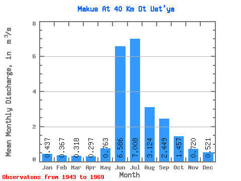
| Statistic | Jan | Feb | Mar | Apr | May | Jun | Jul | Aug | Sep | Oct | Nov | Dec | Annual |
|---|---|---|---|---|---|---|---|---|---|---|---|---|---|
| Mean | 0.44 | 0.37 | 0.32 | 0.30 | 0.76 | 6.59 | 7.01 | 3.12 | 2.45 | 1.46 | 0.72 | 0.52 | 1.97 |
| Standard Deviation | 0.06 | 0.04 | 0.03 | 0.04 | 0.93 | 2.08 | 3.24 | 1.08 | 0.75 | 0.71 | 0.10 | 0.10 | 0.13 |
| Min | 0.35 | 0.32 | 0.27 | 0.22 | 0.23 | 4.01 | 2.31 | 1.32 | 1.77 | 0.81 | 0.57 | 0.40 | 1.79 |
| Max | 0.50 | 0.42 | 0.36 | 0.34 | 2.82 | 9.91 | 12.10 | 4.75 | 4.07 | 2.78 | 0.86 | 0.70 | 2.12 |
| Coefficient of Variation | 0.13 | 0.11 | 0.10 | 0.14 | 1.22 | 0.32 | 0.46 | 0.34 | 0.30 | 0.49 | 0.13 | 0.19 | 0.07 |
 Return to R-Arctic Net Home Page