|
|
|||||||||||||||||
| Point ID: 8053 | Downloads | Plots | Site Data | Code: 1174 |
|
|
|||||||||||||||||
| Download | |
|---|---|
| Site Descriptor Information | Site Time Series Data |
| Link to all available data | |
| View: | Time Series | All |
| Units: | m3/s |
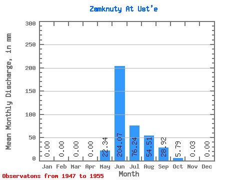
| Statistic | Jan | Feb | Mar | Apr | May | Jun | Jul | Aug | Sep | Oct | Nov | Dec | Annual |
|---|---|---|---|---|---|---|---|---|---|---|---|---|---|
| Mean | 0.00 | 0.00 | 0.00 | 0.00 | 22.34 | 204.07 | 76.25 | 54.50 | 28.91 | 5.80 | 0.04 | 0.00 | 392.47 |
| Standard Deviation | 0.00 | 0.00 | 0.00 | 0.00 | 24.06 | 84.75 | 35.55 | 24.79 | 13.30 | 3.39 | 0.05 | 0.00 | 73.22 |
| Min | 0.00 | 0.00 | 0.00 | 0.00 | 0.00 | 112.81 | 32.00 | 30.32 | 10.11 | 0.64 | 0.00 | 0.00 | 288.14 |
| Max | 0.00 | 0.00 | 0.00 | 0.00 | 63.33 | 329.30 | 138.45 | 101.06 | 46.62 | 12.13 | 0.13 | 0.00 | 489.38 |
| Coefficient of Variation | 1.08 | 0.41 | 0.47 | 0.46 | 0.46 | 0.58 | 1.31 | 0.19 |
 Return to R-Arctic Net Home Page