|
|
|||||||||||||||||
| Point ID: 8053 | Downloads | Plots | Site Data | Code: 1174 |
|
|
|||||||||||||||||
| Download | |
|---|---|
| Site Descriptor Information | Site Time Series Data |
| Link to all available data | |
| View: | Time Series | All |
| Units: | mm |
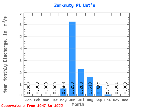
| Statistic | Jan | Feb | Mar | Apr | May | Jun | Jul | Aug | Sep | Oct | Nov | Dec | Annual |
|---|---|---|---|---|---|---|---|---|---|---|---|---|---|
| Mean | 0.00 | 0.00 | 0.00 | 0.00 | 0.66 | 6.26 | 2.26 | 1.62 | 0.89 | 0.17 | 0.00 | 0.00 | 0.99 |
| Standard Deviation | 0.00 | 0.00 | 0.00 | 0.00 | 0.71 | 2.60 | 1.05 | 0.74 | 0.41 | 0.10 | 0.00 | 0.00 | 0.18 |
| Min | 0.00 | 0.00 | 0.00 | 0.00 | 0.00 | 3.46 | 0.95 | 0.90 | 0.31 | 0.02 | 0.00 | 0.00 | 0.73 |
| Max | 0.00 | 0.00 | 0.00 | 0.00 | 1.88 | 10.10 | 4.11 | 3.00 | 1.43 | 0.36 | 0.00 | 0.00 | 1.23 |
| Coefficient of Variation | 1.08 | 0.41 | 0.47 | 0.46 | 0.46 | 0.58 | 1.31 | 0.19 |
 Return to R-Arctic Net Home Page