|
|
|||||||||||||||||
| Point ID: 8053 | Downloads | Plots | Site Data | Code: 1174 |
|
|
|||||||||||||||||
| Download | |
|---|---|
| Site Descriptor Information | Site Time Series Data |
| Link to all available data | |
|
|
| View: | Statistics | Time Series |
| Units: | m3/s |
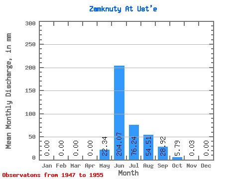
| Statistic | Jan | Feb | Mar | Apr | May | Jun | Jul | Aug | Sep | Oct | Nov | Dec | Annual |
|---|---|---|---|---|---|---|---|---|---|---|---|---|---|
| Mean | 0.00 | 0.00 | 0.00 | 0.00 | 22.34 | 204.07 | 76.25 | 54.50 | 28.91 | 5.80 | 0.04 | 0.00 | 392.47 |
| Standard Deviation | 0.00 | 0.00 | 0.00 | 0.00 | 24.06 | 84.75 | 35.55 | 24.79 | 13.30 | 3.39 | 0.05 | 0.00 | 73.22 |
| Min | 0.00 | 0.00 | 0.00 | 0.00 | 0.00 | 112.81 | 32.00 | 30.32 | 10.11 | 0.64 | 0.00 | 0.00 | 288.14 |
| Max | 0.00 | 0.00 | 0.00 | 0.00 | 63.33 | 329.30 | 138.45 | 101.06 | 46.62 | 12.13 | 0.13 | 0.00 | 489.38 |
| Coefficient of Variation | 1.08 | 0.41 | 0.47 | 0.46 | 0.46 | 0.58 | 1.31 | 0.19 |
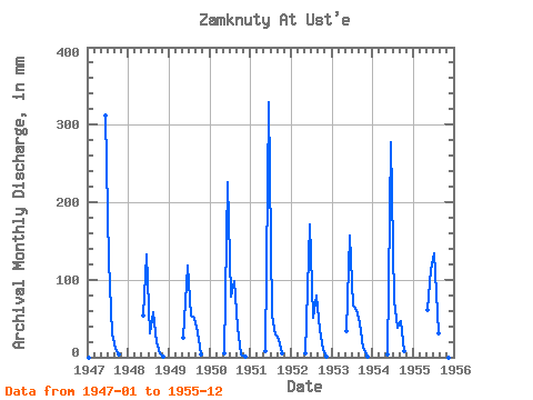
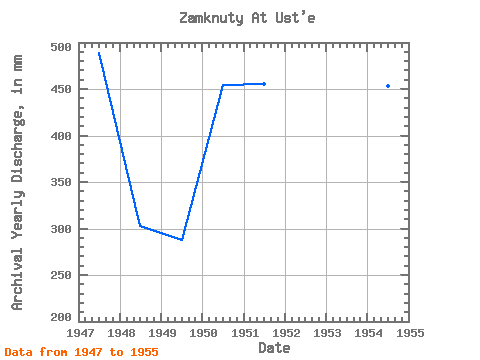
| Year | Jan | Feb | Mar | Apr | May | Jun | Jul | Aug | Sep | Oct | Nov | Dec | Annual | 1947 | 0.00 | 0.00 | 0.00 | 0.00 | 0.00 | 312.04 | 128.38 | 31.35 | 11.43 | 4.40 | 0.00 | 0.00 | 489.38 | 1948 | 0.00 | 0.00 | 0.00 | 0.00 | 55.24 | 132.37 | 32.00 | 59.62 | 19.56 | 4.74 | 0.05 | 0.00 | 303.10 | 1949 | 0.00 | 0.00 | 0.00 | 0.00 | 26.27 | 118.35 | 55.24 | 51.88 | 32.93 | 3.71 | 0.00 | 0.00 | 288.14 | 1950 | 0.00 | 0.00 | 0.00 | 0.00 | 4.72 | 225.94 | 80.51 | 101.06 | 37.49 | 4.04 | 0.10 | 0.00 | 454.31 | 1951 | 0.00 | 0.00 | 0.00 | 0.00 | 8.09 | 329.30 | 54.91 | 30.32 | 23.80 | 5.73 | 0.00 | 0.00 | 455.54 | 1952 | 0.00 | 0.00 | 0.00 | 0.00 | 5.05 | 171.17 | 51.88 | 82.19 | 35.21 | 9.10 | 0.13 | 0.00 | 355.10 | 1953 | 0.00 | 0.00 | 0.00 | 0.00 | 35.37 | 156.50 | 68.72 | 62.99 | 43.04 | 12.13 | 0.07 | 0.00 | 378.52 | 1954 | 0.00 | 0.00 | 0.00 | 0.00 | 3.03 | 278.11 | 76.13 | 39.75 | 46.62 | 7.75 | 0.00 | 0.00 | 453.88 | 1955 | 0.00 | 0.00 | 0.00 | 0.00 | 63.33 | 112.81 | 138.45 | 31.33 | 10.11 | 0.64 | 0.00 | 0.00 | 354.27 |
|---|
 Return to R-Arctic Net Home Page