|
|
|||||||||||||||||
| Point ID: 7893 | Downloads | Plots | Site Data | Code: 3379 |
|
|
|||||||||||||||||
| Download | |
|---|---|
| Site Descriptor Information | Site Time Series Data |
| Link to all available data | |
| View: | Time Series | All |
| Units: | m3/s |
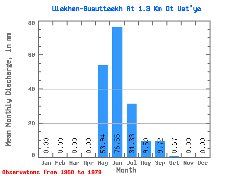
| Statistic | Jan | Feb | Mar | Apr | May | Jun | Jul | Aug | Sep | Oct | Nov | Dec | Annual |
|---|---|---|---|---|---|---|---|---|---|---|---|---|---|
| Mean | 0.00 | 0.00 | 0.00 | 0.00 | 53.93 | 76.55 | 31.32 | 9.50 | 9.72 | 0.67 | 0.00 | 0.00 | 181.24 |
| Standard Deviation | 0.00 | 0.00 | 0.00 | 0.00 | 32.32 | 44.20 | 37.29 | 8.94 | 7.69 | 0.75 | 0.01 | 0.00 | 53.69 |
| Min | 0.00 | 0.00 | 0.00 | 0.00 | 5.63 | 29.39 | 0.30 | 0.00 | 0.00 | 0.00 | 0.00 | 0.00 | 103.96 |
| Max | 0.00 | 0.00 | 0.00 | 0.00 | 101.88 | 161.53 | 117.41 | 22.22 | 26.58 | 2.81 | 0.02 | 0.00 | 282.07 |
| Coefficient of Variation | 0.60 | 0.58 | 1.19 | 0.94 | 0.79 | 1.12 | 2.49 | 0.30 |
 Return to R-Arctic Net Home Page