|
|
|||||||||||||||||
| Point ID: 7893 | Downloads | Plots | Site Data | Code: 3379 |
|
|
|||||||||||||||||
| Download | |
|---|---|
| Site Descriptor Information | Site Time Series Data |
| Link to all available data | |
|
|
| View: | Statistics | Time Series |
| Units: | m3/s |
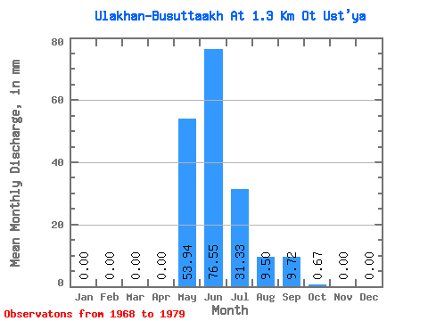
| Statistic | Jan | Feb | Mar | Apr | May | Jun | Jul | Aug | Sep | Oct | Nov | Dec | Annual |
|---|---|---|---|---|---|---|---|---|---|---|---|---|---|
| Mean | 0.00 | 0.00 | 0.00 | 0.00 | 53.93 | 76.55 | 31.32 | 9.50 | 9.72 | 0.67 | 0.00 | 0.00 | 181.24 |
| Standard Deviation | 0.00 | 0.00 | 0.00 | 0.00 | 32.32 | 44.20 | 37.29 | 8.94 | 7.69 | 0.75 | 0.01 | 0.00 | 53.69 |
| Min | 0.00 | 0.00 | 0.00 | 0.00 | 5.63 | 29.39 | 0.30 | 0.00 | 0.00 | 0.00 | 0.00 | 0.00 | 103.96 |
| Max | 0.00 | 0.00 | 0.00 | 0.00 | 101.88 | 161.53 | 117.41 | 22.22 | 26.58 | 2.81 | 0.02 | 0.00 | 282.07 |
| Coefficient of Variation | 0.60 | 0.58 | 1.19 | 0.94 | 0.79 | 1.12 | 2.49 | 0.30 |
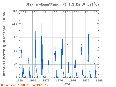
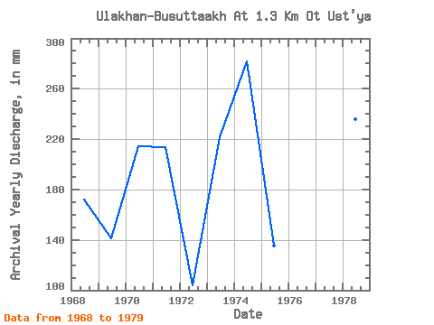
| Year | Jan | Feb | Mar | Apr | May | Jun | Jul | Aug | Sep | Oct | Nov | Dec | Annual | 1968 | 0.00 | 0.00 | 0.00 | 0.00 | 84.61 | 49.96 | 3.88 | 7.67 | 26.58 | 0.30 | 0.00 | 0.00 | 172.39 | 1969 | 0.00 | 0.00 | 0.00 | 0.00 | 61.13 | 46.30 | 26.59 | 0.32 | 7.51 | 0.14 | 0.00 | 0.00 | 141.19 | 1970 | 0.00 | 0.00 | 0.00 | 0.00 | 5.63 | 138.05 | 33.86 | 22.22 | 12.87 | 0.65 | 0.00 | 0.00 | 214.37 | 1971 | 0.00 | 0.00 | 0.00 | 0.00 | 9.22 | 161.53 | 35.51 | 0.80 | 4.51 | 0.56 | 0.00 | 0.00 | 213.74 | 1972 | 0.00 | 0.00 | 0.00 | 0.00 | 52.30 | 50.06 | 1.84 | 0.00 | 0.00 | 0.00 | 0.00 | 0.00 | 103.96 | 1973 | 0.00 | 0.00 | 0.00 | 0.00 | 75.00 | 48.84 | 92.18 | 1.94 | 5.26 | 0.86 | 0.02 | 0.00 | 221.84 | 1974 | 0.00 | 0.00 | 0.00 | 0.00 | 29.50 | 102.36 | 117.41 | 19.99 | 13.25 | 0.88 | 0.00 | 0.00 | 282.07 | 1975 | 0.00 | 0.00 | 0.00 | 0.00 | 101.88 | 29.39 | 0.79 | 0.48 | 4.13 | 0.40 | 0.00 | 0.00 | 135.71 | 1976 | 0.00 | 0.00 | 0.00 | 0.00 | 31.63 | 57.10 | 34.64 | 11.84 | 2.25 | 0.20 | 0.00 | 0.00 | 137.13 | 1977 | 0.00 | 0.00 | 0.00 | 0.00 | 100.91 | 62.08 | 10.38 | 9.51 | 7.61 | 0.17 | 0.00 | 0.00 | 189.51 | 1978 | 0.00 | 0.00 | 0.00 | 0.00 | 52.10 | 129.60 | 18.44 | 21.35 | 13.24 | 1.07 | 0.01 | 0.00 | 236.23 | 1979 | 0.00 | 0.00 | 0.00 | 0.00 | 43.27 | 43.29 | 0.30 | 17.85 | 19.44 | 2.81 | 0.00 | 0.00 | 126.75 |
|---|
 Return to R-Arctic Net Home Page