|
|
|||||||||||||||||
| Point ID: 7893 | Downloads | Plots | Site Data | Code: 3379 |
|
|
|||||||||||||||||
| Download | |
|---|---|
| Site Descriptor Information | Site Time Series Data |
| Link to all available data | |
| View: | Time Series | All |
| Units: | mm |
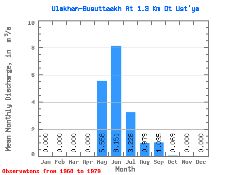
| Statistic | Jan | Feb | Mar | Apr | May | Jun | Jul | Aug | Sep | Oct | Nov | Dec | Annual |
|---|---|---|---|---|---|---|---|---|---|---|---|---|---|
| Mean | 0.00 | 0.00 | 0.00 | 0.00 | 5.56 | 8.15 | 3.23 | 0.98 | 1.03 | 0.07 | 0.00 | 0.00 | 1.58 |
| Standard Deviation | 0.00 | 0.00 | 0.00 | 0.00 | 3.33 | 4.71 | 3.84 | 0.92 | 0.82 | 0.08 | 0.00 | 0.00 | 0.47 |
| Min | 0.00 | 0.00 | 0.00 | 0.00 | 0.58 | 3.13 | 0.03 | 0.00 | 0.00 | 0.00 | 0.00 | 0.00 | 0.91 |
| Max | 0.00 | 0.00 | 0.00 | 0.00 | 10.50 | 17.20 | 12.10 | 2.29 | 2.83 | 0.29 | 0.00 | 0.00 | 2.47 |
| Coefficient of Variation | 0.60 | 0.58 | 1.19 | 0.94 | 0.79 | 1.12 | 2.49 | 0.30 |
 Return to R-Arctic Net Home Page