|
|
|||||||||||||||||
| Point ID: 7879 | Downloads | Plots | Site Data | Code: 3351 |
|
|
|||||||||||||||||
| Download | |
|---|---|
| Site Descriptor Information | Site Time Series Data |
| Link to all available data | |
| View: | Time Series | All |
| Units: | m3/s |
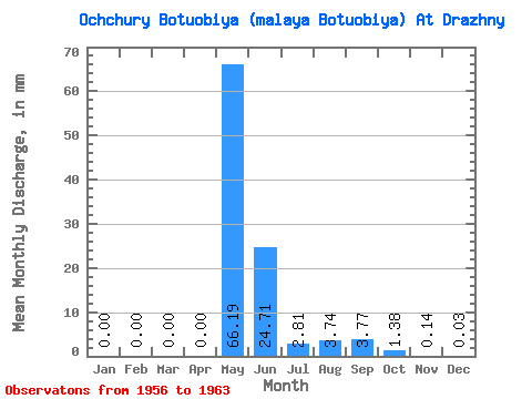
| Statistic | Jan | Feb | Mar | Apr | May | Jun | Jul | Aug | Sep | Oct | Nov | Dec | Annual |
|---|---|---|---|---|---|---|---|---|---|---|---|---|---|
| Mean | 0.00 | 0.00 | 0.00 | 0.00 | 66.19 | 24.70 | 2.81 | 3.74 | 3.77 | 1.38 | 0.14 | 0.04 | 108.76 |
| Standard Deviation | 0.01 | 0.00 | 0.00 | 0.00 | 24.11 | 13.99 | 3.83 | 3.71 | 3.98 | 1.26 | 0.11 | 0.06 | 27.69 |
| Min | 0.00 | 0.00 | 0.00 | 0.00 | 21.23 | 8.22 | 0.00 | 0.00 | 0.00 | 0.00 | 0.00 | 0.00 | 63.20 |
| Max | 0.01 | 0.00 | 0.00 | 0.00 | 90.63 | 46.62 | 10.57 | 8.57 | 11.26 | 3.58 | 0.27 | 0.15 | 137.54 |
| Coefficient of Variation | 1.71 | 0.36 | 0.57 | 1.36 | 0.99 | 1.06 | 0.91 | 0.79 | 1.72 | 0.26 |
 Return to R-Arctic Net Home Page