|
|
|||||||||||||||||
| Point ID: 7879 | Downloads | Plots | Site Data | Code: 3351 |
|
|
|||||||||||||||||
| Download | |
|---|---|
| Site Descriptor Information | Site Time Series Data |
| Link to all available data | |
|
|
| View: | Statistics | Time Series |
| Units: | m3/s |
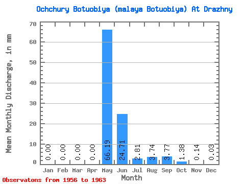
| Statistic | Jan | Feb | Mar | Apr | May | Jun | Jul | Aug | Sep | Oct | Nov | Dec | Annual |
|---|---|---|---|---|---|---|---|---|---|---|---|---|---|
| Mean | 0.00 | 0.00 | 0.00 | 0.00 | 66.19 | 24.70 | 2.81 | 3.74 | 3.77 | 1.38 | 0.14 | 0.04 | 108.76 |
| Standard Deviation | 0.01 | 0.00 | 0.00 | 0.00 | 24.11 | 13.99 | 3.83 | 3.71 | 3.98 | 1.26 | 0.11 | 0.06 | 27.69 |
| Min | 0.00 | 0.00 | 0.00 | 0.00 | 21.23 | 8.22 | 0.00 | 0.00 | 0.00 | 0.00 | 0.00 | 0.00 | 63.20 |
| Max | 0.01 | 0.00 | 0.00 | 0.00 | 90.63 | 46.62 | 10.57 | 8.57 | 11.26 | 3.58 | 0.27 | 0.15 | 137.54 |
| Coefficient of Variation | 1.71 | 0.36 | 0.57 | 1.36 | 0.99 | 1.06 | 0.91 | 0.79 | 1.72 | 0.26 |
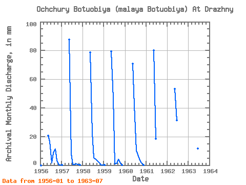
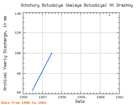
| Year | Jan | Feb | Mar | Apr | May | Jun | Jul | Aug | Sep | Oct | Nov | Dec | Annual | 1956 | 0.00 | 0.00 | 0.00 | 0.00 | 21.23 | 16.75 | 1.71 | 8.57 | 11.26 | 3.58 | 0.26 | 0.06 | 63.20 | 1957 | 0.01 | 0.00 | 0.00 | 0.00 | 90.63 | 8.22 | 0.47 | 0.54 | 0.91 | 0.38 | 0.06 | 0.00 | 99.70 | 1958 | 0.00 | 0.00 | 0.00 | 0.00 | 81.24 | 22.48 | 5.18 | 4.16 | 2.91 | 1.53 | 0.27 | 0.15 | 116.65 | 1959 | 0.01 | 0.00 | 0.00 | 0.00 | 82.06 | 46.62 | 0.78 | 1.46 | 3.99 | 1.13 | 0.15 | 0.00 | 135.41 | 1960 | 0.00 | 0.00 | 0.00 | 0.00 | 73.07 | 41.88 | 10.57 | 7.72 | 3.54 | 1.65 | 0.10 | 0.00 | 137.54 | 1961 | 0.00 | 0.00 | 0.00 | 0.00 | 82.87 | 18.41 | 0.00 | 0.00 | 0.00 | 0.00 | 0.00 | 0.00 | 100.07 | 1962 | 0.00 | 0.00 | 0.00 | 0.00 | 55.11 | 31.53 | 1963 | 43.27 | 11.73 | 0.95 |
|---|
 Return to R-Arctic Net Home Page