|
|
|||||||||||||||||
| Point ID: 7879 | Downloads | Plots | Site Data | Code: 3351 |
|
|
|||||||||||||||||
| Download | |
|---|---|
| Site Descriptor Information | Site Time Series Data |
| Link to all available data | |
| View: | Time Series | All |
| Units: | mm |
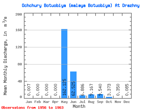
| Statistic | Jan | Feb | Mar | Apr | May | Jun | Jul | Aug | Sep | Oct | Nov | Dec | Annual |
|---|---|---|---|---|---|---|---|---|---|---|---|---|---|
| Mean | 0.01 | 0.00 | 0.00 | 0.00 | 162.12 | 62.52 | 6.89 | 9.17 | 9.54 | 3.37 | 0.35 | 0.09 | 22.61 |
| Standard Deviation | 0.01 | 0.00 | 0.00 | 0.00 | 59.07 | 35.41 | 9.38 | 9.09 | 10.08 | 3.08 | 0.28 | 0.15 | 5.76 |
| Min | 0.00 | 0.00 | 0.00 | 0.00 | 52.00 | 20.80 | 0.00 | 0.00 | 0.00 | 0.00 | 0.00 | 0.00 | 13.14 |
| Max | 0.03 | 0.00 | 0.00 | 0.00 | 222.00 | 118.00 | 25.90 | 21.00 | 28.50 | 8.76 | 0.69 | 0.36 | 28.59 |
| Coefficient of Variation | 1.71 | 0.36 | 0.57 | 1.36 | 0.99 | 1.06 | 0.91 | 0.79 | 1.72 | 0.26 |
 Return to R-Arctic Net Home Page