|
|
|||||||||||||||||
| Point ID: 7693 | Downloads | Plots | Site Data | Other Close Sites | Code: 15356000 |
|
|
|||||||||||||||||
| Download | |
|---|---|
| Site Descriptor Information | Site Time Series Data |
| Link to all available data | |
| View: | Time Series | All |
| Units: | m3/s |
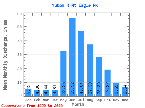
| Statistic | Jan | Feb | Mar | Apr | May | Jun | Jul | Aug | Sep | Oct | Nov | Dec | Annual |
|---|---|---|---|---|---|---|---|---|---|---|---|---|---|
| Mean | 5.43 | 4.42 | 4.44 | 4.81 | 32.26 | 55.92 | 47.03 | 37.37 | 28.20 | 19.32 | 9.55 | 6.64 | 256.44 |
| Standard Deviation | 1.22 | 0.96 | 0.96 | 1.56 | 9.07 | 15.85 | 9.42 | 6.46 | 5.28 | 4.21 | 2.27 | 1.47 | 37.20 |
| Min | 2.32 | 1.69 | 2.01 | 2.16 | 15.94 | 30.19 | 28.08 | 22.88 | 17.65 | 11.83 | 5.99 | 3.35 | 181.74 |
| Max | 7.84 | 6.58 | 6.57 | 10.37 | 51.98 | 114.05 | 69.52 | 51.70 | 46.91 | 34.38 | 15.61 | 10.03 | 334.23 |
| Coefficient of Variation | 0.22 | 0.22 | 0.22 | 0.32 | 0.28 | 0.28 | 0.20 | 0.17 | 0.19 | 0.22 | 0.24 | 0.22 | 0.14 |
| Other Close Sites | ||||||
|---|---|---|---|---|---|---|
| PointID | Latitude | Longitude | Drainage Area | Source | Name | |
| 5832 | "YUKON RIVER AT EAGLE" | 64.78 | 2167698 | Hydat | ||
 Return to R-Arctic Net Home Page