|
|
|||||||||||||||||
| Point ID: 5832 | Downloads | Plots | Site Data | Other Close Sites | Code: 09ED001 |
|
|
|||||||||||||||||
| Download | |
|---|---|
| Site Descriptor Information | Site Time Series Data |
| Link to all available data | |
| View: | Time Series | All |
| Units: | m3/s |
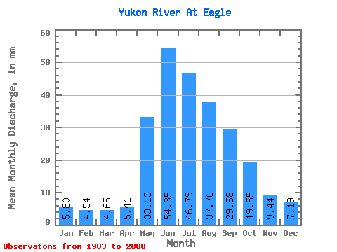
| Statistic | Jan | Feb | Mar | Apr | May | Jun | Jul | Aug | Sep | Oct | Nov | Dec | Annual |
|---|---|---|---|---|---|---|---|---|---|---|---|---|---|
| Mean | 5.80 | 4.58 | 4.65 | 5.41 | 33.12 | 54.35 | 46.78 | 37.76 | 29.58 | 19.54 | 9.44 | 7.18 | 264.81 |
| Standard Deviation | 0.95 | 0.68 | 0.63 | 1.75 | 8.72 | 13.97 | 11.30 | 7.94 | 7.00 | 4.37 | 2.02 | 1.09 | 34.76 |
| Min | 4.34 | 3.29 | 3.72 | 3.29 | 19.22 | 34.38 | 28.05 | 22.86 | 17.63 | 15.21 | 6.79 | 6.10 | 199.66 |
| Max | 7.83 | 6.22 | 6.21 | 10.40 | 47.91 | 93.45 | 69.50 | 51.74 | 46.90 | 27.05 | 12.78 | 9.47 | 316.14 |
| Coefficient of Variation | 0.16 | 0.15 | 0.14 | 0.32 | 0.26 | 0.26 | 0.24 | 0.21 | 0.24 | 0.22 | 0.21 | 0.15 | 0.13 |
| Other Close Sites | ||||||
|---|---|---|---|---|---|---|
| PointID | Latitude | Longitude | Drainage Area | Source | Name | |
| 7693 | "YUKON R AT EAGLE AK" | 64.78 | 2167698 | USGS | ||
 Return to R-Arctic Net Home Page