|
|
|||||||||||||||||
| Point ID: 7693 | Downloads | Plots | Site Data | Other Close Sites | Code: 15356000 |
|
|
|||||||||||||||||
| Download | |
|---|---|
| Site Descriptor Information | Site Time Series Data |
| Link to all available data | |
| View: | Time Series | All |
| Units: | mm |
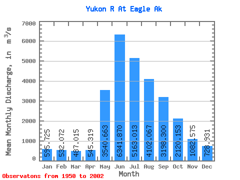
| Statistic | Jan | Feb | Mar | Apr | May | Jun | Jul | Aug | Sep | Oct | Nov | Dec | Annual |
|---|---|---|---|---|---|---|---|---|---|---|---|---|---|
| Mean | 595.73 | 532.07 | 487.01 | 545.32 | 3540.66 | 6341.87 | 5163.01 | 4102.07 | 3198.30 | 2120.15 | 1082.58 | 728.93 | 2388.65 |
| Standard Deviation | 133.73 | 116.17 | 105.11 | 176.90 | 995.34 | 1797.14 | 1034.12 | 709.67 | 598.90 | 461.86 | 257.63 | 161.03 | 346.50 |
| Min | 254.85 | 203.88 | 220.87 | 244.94 | 1749.13 | 3423.51 | 3082.43 | 2511.98 | 2001.81 | 1298.89 | 679.60 | 368.12 | 1692.83 |
| Max | 860.47 | 792.87 | 721.51 | 1176.00 | 5705.85 | 12935.14 | 7631.39 | 5675.24 | 5319.79 | 3773.90 | 1769.80 | 1100.70 | 3113.18 |
| Coefficient of Variation | 0.22 | 0.22 | 0.22 | 0.32 | 0.28 | 0.28 | 0.20 | 0.17 | 0.19 | 0.22 | 0.24 | 0.22 | 0.14 |
| Other Close Sites | ||||||
|---|---|---|---|---|---|---|
| PointID | Latitude | Longitude | Drainage Area | Source | Name | |
| 5832 | "YUKON RIVER AT EAGLE" | 64.78 | 2167698 | Hydat | ||
 Return to R-Arctic Net Home Page