|
|
|||||||||||||||||
| Point ID: 7687 | Downloads | Plots | Site Data | Code: 15744000 |
|
|
|||||||||||||||||
| Download | |
|---|---|
| Site Descriptor Information | Site Time Series Data |
| Link to all available data | |
| View: | Time Series | All |
| Units: | m3/s |
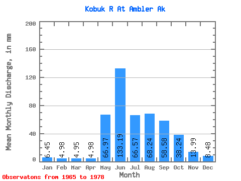
| Statistic | Jan | Feb | Mar | Apr | May | Jun | Jul | Aug | Sep | Oct | Nov | Dec | Annual |
|---|---|---|---|---|---|---|---|---|---|---|---|---|---|
| Mean | 6.45 | 5.02 | 4.95 | 4.98 | 66.96 | 133.19 | 66.56 | 68.23 | 58.58 | 38.23 | 13.99 | 8.48 | 464.56 |
| Standard Deviation | 2.01 | 1.43 | 1.23 | 0.91 | 32.91 | 74.16 | 30.82 | 42.09 | 31.90 | 20.44 | 4.49 | 2.69 | 157.83 |
| Min | 4.01 | 3.36 | 3.56 | 3.88 | 17.57 | 33.67 | 23.32 | 29.89 | 21.41 | 13.25 | 6.81 | 4.40 | 260.03 |
| Max | 10.80 | 8.35 | 7.87 | 7.11 | 134.68 | 264.30 | 137.98 | 177.04 | 143.33 | 82.75 | 21.55 | 13.59 | 814.84 |
| Coefficient of Variation | 0.31 | 0.28 | 0.25 | 0.18 | 0.49 | 0.56 | 0.46 | 0.62 | 0.55 | 0.54 | 0.32 | 0.32 | 0.34 |
 Return to R-Arctic Net Home Page