|
|
|||||||||||||||||
| Point ID: 7687 | Downloads | Plots | Site Data | Code: 15744000 |
|
|
|||||||||||||||||
| Download | |
|---|---|
| Site Descriptor Information | Site Time Series Data |
| Link to all available data | |
| View: | Time Series | All |
| Units: | mm |
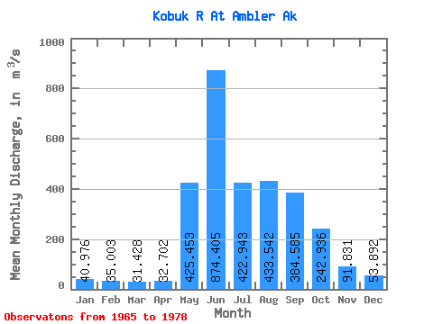
| Statistic | Jan | Feb | Mar | Apr | May | Jun | Jul | Aug | Sep | Oct | Nov | Dec | Annual |
|---|---|---|---|---|---|---|---|---|---|---|---|---|---|
| Mean | 40.98 | 35.00 | 31.43 | 32.70 | 425.45 | 874.40 | 422.94 | 433.54 | 384.58 | 242.94 | 91.83 | 53.89 | 250.47 |
| Standard Deviation | 12.76 | 9.95 | 7.84 | 5.99 | 209.11 | 486.88 | 195.80 | 267.47 | 209.41 | 129.89 | 29.45 | 17.11 | 85.10 |
| Min | 25.47 | 23.40 | 22.64 | 25.47 | 111.64 | 221.02 | 148.15 | 189.89 | 140.57 | 84.16 | 44.71 | 27.93 | 140.20 |
| Max | 68.66 | 58.21 | 50.03 | 46.70 | 855.79 | 1735.07 | 876.73 | 1124.92 | 940.98 | 525.81 | 141.50 | 86.37 | 439.34 |
| Coefficient of Variation | 0.31 | 0.28 | 0.25 | 0.18 | 0.49 | 0.56 | 0.46 | 0.62 | 0.55 | 0.54 | 0.32 | 0.32 | 0.34 |
 Return to R-Arctic Net Home Page