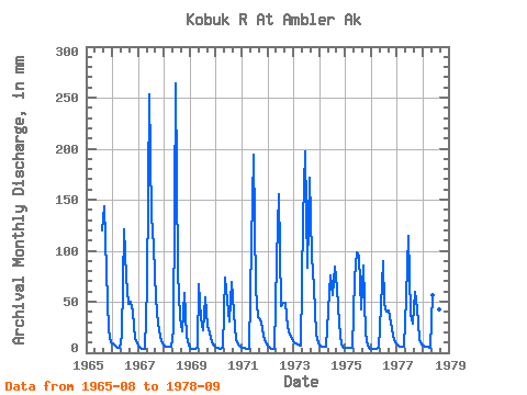
| Point ID: 7687 | Downloads | Plots | Site Data | Code: 15744000 |
| Download | |
|---|---|
| Site Descriptor Information | Site Time Series Data |
| Link to all available data | |

|

|
| View: | Statistics | Time Series |
| Units: | m3/s |
| Statistic | Jan | Feb | Mar | Apr | May | Jun | Jul | Aug | Sep | Oct | Nov | Dec | Annual |
|---|---|---|---|---|---|---|---|---|---|---|---|---|---|
| Mean | 6.45 | 5.02 | 4.95 | 4.98 | 66.96 | 133.19 | 66.56 | 68.23 | 58.58 | 38.23 | 13.99 | 8.48 | 464.56 |
| Standard Deviation | 2.01 | 1.43 | 1.23 | 0.91 | 32.91 | 74.16 | 30.82 | 42.09 | 31.90 | 20.44 | 4.49 | 2.69 | 157.83 |
| Min | 4.01 | 3.36 | 3.56 | 3.88 | 17.57 | 33.67 | 23.32 | 29.89 | 21.41 | 13.25 | 6.81 | 4.40 | 260.03 |
| Max | 10.80 | 8.35 | 7.87 | 7.11 | 134.68 | 264.30 | 137.98 | 177.04 | 143.33 | 82.75 | 21.55 | 13.59 | 814.84 |
| Coefficient of Variation | 0.31 | 0.28 | 0.25 | 0.18 | 0.49 | 0.56 | 0.46 | 0.62 | 0.55 | 0.54 | 0.32 | 0.32 | 0.34 |
| Year | Jan | Feb | Mar | Apr | May | Jun | Jul | Aug | Sep | Oct | Nov | Dec | Annual | 1965 | 124.17 | 143.33 | 82.75 | 21.55 | 10.69 | 1966 | 8.91 | 6.49 | 4.45 | 5.17 | 17.57 | 121.22 | 76.61 | 49.79 | 49.70 | 41.89 | 12.93 | 8.91 | 403.20 | 1967 | 5.79 | 3.65 | 3.56 | 4.09 | 67.43 | 253.17 | 137.98 | 106.80 | 53.28 | 29.78 | 15.51 | 9.31 | 688.97 | 1968 | 6.88 | 5.68 | 5.79 | 5.60 | 22.35 | 264.30 | 81.95 | 36.19 | 21.41 | 60.22 | 15.35 | 6.68 | 533.40 | 1969 | 4.28 | 3.36 | 3.56 | 5.00 | 69.26 | 33.67 | 23.32 | 55.76 | 25.82 | 20.57 | 10.61 | 6.75 | 260.03 | 1970 | 5.26 | 4.13 | 4.41 | 4.38 | 76.34 | 51.26 | 31.98 | 71.62 | 38.96 | 13.25 | 7.97 | 5.78 | 313.42 | 1971 | 4.60 | 4.06 | 4.23 | 3.88 | 110.94 | 194.03 | 65.16 | 36.16 | 32.63 | 30.78 | 16.52 | 10.63 | 512.86 | 1972 | 6.80 | 4.67 | 4.34 | 3.88 | 93.49 | 155.88 | 47.34 | 50.69 | 49.45 | 25.77 | 17.82 | 13.59 | 473.07 | 1973 | 10.80 | 8.35 | 7.87 | 7.11 | 134.68 | 197.13 | 86.23 | 177.04 | 94.49 | 66.58 | 18.61 | 9.46 | 814.84 | 1974 | 7.42 | 5.83 | 6.08 | 5.63 | 42.24 | 75.78 | 58.21 | 87.34 | 64.32 | 29.24 | 8.39 | 4.89 | 393.86 | 1975 | 4.45 | 4.06 | 4.45 | 4.80 | 74.65 | 98.59 | 96.87 | 43.60 | 85.48 | 19.98 | 6.81 | 4.40 | 446.88 | 1976 | 4.01 | 3.65 | 4.01 | 4.32 | 47.52 | 90.05 | 49.39 | 42.14 | 41.51 | 31.05 | 16.38 | 10.99 | 344.15 | 1977 | 7.90 | 5.64 | 5.79 | 5.68 | 55.90 | 114.84 | 37.99 | 29.89 | 59.79 | 45.16 | 13.39 | 8.19 | 390.01 | 1978 | 6.74 | 5.68 | 5.75 | 5.20 | 58.08 | 81.60 | 72.29 | 44.03 | 59.96 |
|---|
 Return to R-Arctic Net Home Page