|
|
|||||||||||||||||
| Point ID: 7565 | Downloads | Plots | Site Data | Code: 70827 |
|
|
|||||||||||||||||
| Download | |
|---|---|
| Site Descriptor Information | Site Time Series Data |
| Link to all available data | |
| View: | Time Series | All |
| Units: | m3/s |
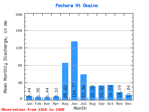
| Statistic | Jan | Feb | Mar | Apr | May | Jun | Jul | Aug | Sep | Oct | Nov | Dec | Annual |
|---|---|---|---|---|---|---|---|---|---|---|---|---|---|
| Mean | 9.44 | 7.01 | 6.44 | 8.10 | 85.61 | 134.77 | 59.35 | 32.07 | 33.52 | 34.53 | 18.09 | 11.83 | 442.98 |
| Standard Deviation | 3.37 | 2.59 | 2.24 | 6.44 | 47.55 | 36.10 | 19.56 | 8.11 | 10.92 | 14.14 | 6.87 | 3.66 | 58.83 |
| Min | 3.36 | 0.67 | 0.42 | 2.23 | 7.35 | 61.81 | 32.02 | 17.77 | 13.79 | 3.55 | 8.18 | 5.80 | 315.52 |
| Max | 17.34 | 15.33 | 13.39 | 30.91 | 205.14 | 250.89 | 107.01 | 52.70 | 58.40 | 64.03 | 36.22 | 20.43 | 561.22 |
| Coefficient of Variation | 0.36 | 0.37 | 0.35 | 0.80 | 0.56 | 0.27 | 0.33 | 0.25 | 0.33 | 0.41 | 0.38 | 0.31 | 0.13 |
 Return to R-Arctic Net Home Page