|
|
|||||||||||||||||
| Point ID: 7565 | Downloads | Plots | Site Data | Code: 70827 |
|
|
|||||||||||||||||
| Download | |
|---|---|
| Site Descriptor Information | Site Time Series Data |
| Link to all available data | |
|
|
| View: | Statistics | Time Series |
| Units: | m3/s |
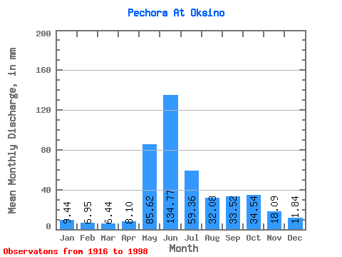
| Statistic | Jan | Feb | Mar | Apr | May | Jun | Jul | Aug | Sep | Oct | Nov | Dec | Annual |
|---|---|---|---|---|---|---|---|---|---|---|---|---|---|
| Mean | 9.44 | 7.01 | 6.44 | 8.10 | 85.61 | 134.77 | 59.35 | 32.07 | 33.52 | 34.53 | 18.09 | 11.83 | 442.98 |
| Standard Deviation | 3.37 | 2.59 | 2.24 | 6.44 | 47.55 | 36.10 | 19.56 | 8.11 | 10.92 | 14.14 | 6.87 | 3.66 | 58.83 |
| Min | 3.36 | 0.67 | 0.42 | 2.23 | 7.35 | 61.81 | 32.02 | 17.77 | 13.79 | 3.55 | 8.18 | 5.80 | 315.52 |
| Max | 17.34 | 15.33 | 13.39 | 30.91 | 205.14 | 250.89 | 107.01 | 52.70 | 58.40 | 64.03 | 36.22 | 20.43 | 561.22 |
| Coefficient of Variation | 0.36 | 0.37 | 0.35 | 0.80 | 0.56 | 0.27 | 0.33 | 0.25 | 0.33 | 0.41 | 0.38 | 0.31 | 0.13 |
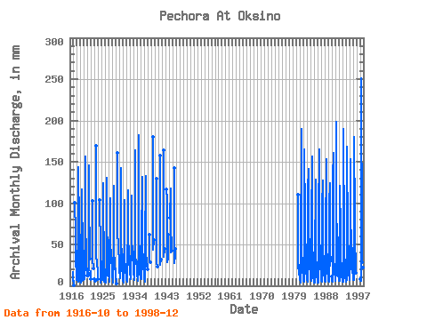
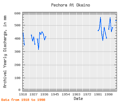
| Year | Jan | Feb | Mar | Apr | May | Jun | Jul | Aug | Sep | Oct | Nov | Dec | Annual | 1916 | 16.82 | 8.27 | 6.34 | 1917 | 6.04 | 0.67 | 0.42 | 103.86 | 96.37 | 70.56 | 23.95 | 22.60 | 44.03 | 13.79 | 7.42 | 1918 | 6.88 | 6.55 | 7.61 | 4.43 | 7.35 | 143.72 | 72.53 | 43.00 | 56.66 | 64.03 | 23.93 | 5.80 | 442.64 | 1919 | 3.36 | 7.10 | 4.24 | 7.13 | 51.59 | 116.31 | 35.71 | 32.70 | 29.41 | 43.69 | 13.62 | 7.08 | 351.73 | 1920 | 8.07 | 7.70 | 9.18 | 26.50 | 161.37 | 62.14 | 52.96 | 38.71 | 25.92 | 17.25 | 12.63 | 1921 | 13.30 | 15.33 | 13.39 | 21.60 | 150.21 | 109.66 | 34.42 | 13.79 | 18.20 | 8.18 | 1922 | 103.02 | 32.02 | 23.60 | 20.93 | 1923 | 7.84 | 7.26 | 6.55 | 169.48 | 38.88 | 28.84 | 24.92 | 28.93 | 16.03 | 8.00 | 1924 | 103.85 | 96.99 | 50.21 | 41.21 | 3.55 | 19.11 | 15.45 | 1925 | 15.45 | 9.38 | 6.73 | 9.80 | 51.59 | 124.61 | 104.72 | 30.90 | 34.98 | 4.51 | 19.61 | 13.22 | 424.92 | 1926 | 5.97 | 4.48 | 4.98 | 3.31 | 19.23 | 130.43 | 83.17 | 39.91 | 28.99 | 29.53 | 17.20 | 14.25 | 380.90 | 1927 | 14.16 | 7.59 | 7.83 | 5.29 | 109.87 | 103.02 | 33.48 | 30.21 | 34.64 | 45.49 | 9.80 | 11.67 | 411.35 | 1928 | 11.16 | 7.90 | 4.74 | 3.40 | 66.78 | 121.29 | 46.78 | 24.03 | 19.94 | 32.36 | 10.63 | 8.03 | 356.45 | 1929 | 9.53 | 7.67 | 8.58 | 2.23 | 160.34 | 68.67 | 48.92 | 43.53 | 39.14 | 36.22 | 17.68 | 1930 | 16.65 | 12.28 | 10.39 | 9.30 | 26.09 | 142.89 | 59.74 | 33.90 | 29.49 | 29.53 | 16.03 | 9.10 | 395.93 | 1931 | 6.20 | 5.40 | 5.12 | 3.81 | 76.22 | 103.85 | 36.74 | 17.77 | 15.45 | 25.41 | 12.79 | 7.50 | 315.52 | 1932 | 7.56 | 4.75 | 4.51 | 4.79 | 96.13 | 115.48 | 70.30 | 27.21 | 25.01 | 49.78 | 25.09 | 18.20 | 446.77 | 1933 | 17.34 | 7.23 | 8.09 | 8.39 | 53.82 | 108.83 | 63.09 | 35.79 | 41.70 | 46.87 | 24.76 | 14.08 | 428.96 | 1934 | 14.51 | 12.28 | 7.33 | 7.97 | 77.25 | 163.66 | 39.83 | 27.64 | 26.17 | 26.69 | 29.41 | 16.82 | 450.08 | 1935 | 13.05 | 8.52 | 9.10 | 5.70 | 19.83 | 181.94 | 67.81 | 31.93 | 27.08 | 40.08 | 15.95 | 11.59 | 433.16 | 1936 | 9.70 | 7.98 | 9.44 | 8.97 | 52.70 | 131.26 | 37.25 | 25.58 | 28.58 | 38.97 | 26.67 | 11.93 | 389.19 | 1937 | 13.39 | 9.54 | 5.20 | 7.82 | 47.81 | 132.92 | 58.28 | 27.55 | 23.26 | 32.87 | 33.98 | 20.43 | 413.02 | 1938 | 61.81 | 47.38 | 30.13 | 28.25 | 1939 | 180.28 | 72.36 | 44.98 | 55.74 | 1940 | 129.60 | 86.69 | 29.01 | 22.68 | 23.78 | 1941 | 157.01 | 55.10 | 26.44 | 31.24 | 1942 | 164.49 | 55.96 | 35.96 | 44.36 | 1943 | 120.17 | 103.85 | 41.54 | 29.70 | 34.39 | 63.60 | 1944 | 85.15 | 117.97 | 62.83 | 41.97 | 58.40 | 44.20 | 1945 | 142.06 | 44.55 | 28.75 | 35.72 | 45.92 | 1980 | 110.38 | 42.63 | 21.27 | 23.87 | 25.87 | 15.83 | 11.06 | 1981 | 7.82 | 6.42 | 5.61 | 4.22 | 32.37 | 190.16 | 90.00 | 25.62 | 33.59 | 33.74 | 18.30 | 10.30 | 458.58 | 1982 | 8.89 | 5.98 | 5.38 | 5.87 | 170.38 | 82.30 | 53.90 | 35.58 | 49.66 | 25.97 | 14.90 | 13.68 | 469.57 | 1983 | 9.66 | 7.07 | 4.64 | 9.99 | 120.80 | 141.40 | 77.41 | 42.28 | 52.95 | 58.16 | 25.36 | 13.42 | 561.22 | 1984 | 10.20 | 7.75 | 6.98 | 6.08 | 77.47 | 156.49 | 75.27 | 24.27 | 39.80 | 19.00 | 9.55 | 7.94 | 440.53 | 1985 | 5.89 | 4.05 | 4.70 | 4.25 | 30.11 | 128.44 | 107.01 | 27.59 | 25.89 | 28.93 | 11.62 | 7.68 | 385.19 | 1986 | 4.67 | 3.69 | 4.03 | 3.62 | 84.78 | 165.50 | 62.07 | 34.92 | 48.61 | 36.00 | 24.85 | 13.68 | 485.94 | 1987 | 7.49 | 5.27 | 5.12 | 4.61 | 97.85 | 127.11 | 76.91 | 43.95 | 30.99 | 21.72 | 14.21 | 9.18 | 442.70 | 1988 | 7.31 | 5.15 | 5.48 | 5.96 | 60.34 | 152.86 | 57.25 | 21.89 | 20.52 | 39.48 | 15.54 | 11.50 | 402.90 | 1989 | 7.40 | 5.56 | 5.59 | 5.28 | 102.14 | 124.61 | 32.70 | 24.98 | 34.06 | 11.16 | 1990 | 7.37 | 5.54 | 5.43 | 6.31 | 135.43 | 160.56 | 46.33 | 27.67 | 26.16 | 25.63 | 12.94 | 11.39 | 469.58 | 1991 | 8.76 | 6.73 | 6.58 | 16.70 | 205.14 | 115.48 | 36.31 | 28.75 | 39.88 | 60.43 | 25.09 | 11.93 | 558.76 | 1992 | 9.61 | 7.48 | 6.14 | 5.92 | 123.60 | 120.46 | 67.47 | 31.67 | 30.41 | 24.98 | 12.96 | 11.16 | 450.00 | 1993 | 8.07 | 4.97 | 5.57 | 5.23 | 99.57 | 190.25 | 55.19 | 25.49 | 33.15 | 31.24 | 13.71 | 9.18 | 481.36 | 1994 | 7.42 | 6.27 | 5.54 | 7.52 | 100.42 | 168.65 | 58.20 | 28.15 | 29.33 | 49.87 | 16.86 | 14.33 | 491.58 | 1995 | 9.61 | 7.08 | 8.02 | 30.91 | 157.93 | 86.40 | 49.95 | 39.40 | 44.03 | 46.87 | 22.18 | 17.94 | 517.65 | 1996 | 11.16 | 6.95 | 7.13 | 7.00 | 73.47 | 180.28 | 83.26 | 52.70 | 44.28 | 35.02 | 17.95 | 15.79 | 534.19 | 1998 | 8.17 | 6.64 | 6.46 | 5.38 | 33.05 | 250.89 | 47.12 | 29.87 | 43.12 | 32.19 | 21.93 | 11.93 | 498.94 |
|---|
 Return to R-Arctic Net Home Page