|
|
|||||||||||||||||
| Point ID: 7565 | Downloads | Plots | Site Data | Code: 70827 |
|
|
|||||||||||||||||
| Download | |
|---|---|
| Site Descriptor Information | Site Time Series Data |
| Link to all available data | |
| View: | Time Series | All |
| Units: | mm |
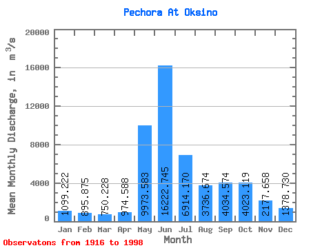
| Statistic | Jan | Feb | Mar | Apr | May | Jun | Jul | Aug | Sep | Oct | Nov | Dec | Annual |
|---|---|---|---|---|---|---|---|---|---|---|---|---|---|
| Mean | 1099.22 | 895.88 | 750.23 | 974.59 | 9973.58 | 16222.75 | 6914.17 | 3736.67 | 4034.57 | 4023.12 | 2177.66 | 1378.73 | 4379.24 |
| Standard Deviation | 392.57 | 330.80 | 260.75 | 775.44 | 5539.51 | 4344.98 | 2278.44 | 944.48 | 1314.41 | 1647.07 | 827.15 | 426.60 | 581.56 |
| Min | 391.00 | 85.50 | 49.20 | 269.00 | 856.00 | 7440.00 | 3730.00 | 2070.00 | 1660.00 | 414.00 | 984.00 | 676.00 | 3119.17 |
| Max | 2020.00 | 1960.00 | 1560.00 | 3720.00 | 23900.00 | 30200.00 | 12467.00 | 6140.00 | 7030.00 | 7460.00 | 4360.00 | 2380.00 | 5548.17 |
| Coefficient of Variation | 0.36 | 0.37 | 0.35 | 0.80 | 0.56 | 0.27 | 0.33 | 0.25 | 0.33 | 0.41 | 0.38 | 0.31 | 0.13 |
 Return to R-Arctic Net Home Page