|
|
|||||||||||||||||
| Point ID: 7446 | Downloads | Plots | Site Data | Code: 70343 |
|
|
|||||||||||||||||
| Download | |
|---|---|
| Site Descriptor Information | Site Time Series Data |
| Link to all available data | |
| View: | Time Series | All |
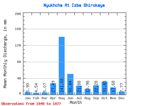
| Units: | m3/s |
| Statistic | Jan | Feb | Mar | Apr | May | Jun | Jul | Aug | Sep | Oct | Nov | Dec | Annual |
|---|---|---|---|---|---|---|---|---|---|---|---|---|---|
| Mean | 5.90 | 4.58 | 5.07 | 27.49 | 141.01 | 50.84 | 21.87 | 13.98 | 22.28 | 31.82 | 17.68 | 7.77 | 347.35 |
| Standard Deviation | 1.77 | 1.44 | 1.67 | 32.64 | 48.83 | 27.65 | 14.28 | 10.31 | 16.18 | 22.88 | 11.74 | 2.82 | 67.40 |
| Min | 3.50 | 2.29 | 2.84 | 3.42 | 37.70 | 16.30 | 6.55 | 5.03 | 6.78 | 7.90 | 5.21 | 4.34 | 255.83 |
| Max | 11.61 | 9.73 | 11.97 | 119.61 | 258.23 | 103.10 | 55.06 | 48.47 | 65.74 | 107.12 | 49.81 | 15.62 | 560.64 |
| Coefficient of Variation | 0.30 | 0.32 | 0.33 | 1.19 | 0.35 | 0.54 | 0.65 | 0.74 | 0.73 | 0.72 | 0.66 | 0.36 | 0.19 |
 Return to R-Arctic Net Home Page