|
|
|||||||||||||||||
| Point ID: 7446 | Downloads | Plots | Site Data | Code: 70343 |
|
|
|||||||||||||||||
| Download | |
|---|---|
| Site Descriptor Information | Site Time Series Data |
| Link to all available data | |
| View: | Time Series | All |
| Units: | mm |
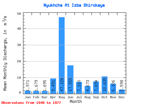
| Statistic | Jan | Feb | Mar | Apr | May | Jun | Jul | Aug | Sep | Oct | Nov | Dec | Annual |
|---|---|---|---|---|---|---|---|---|---|---|---|---|---|
| Mean | 1.97 | 1.68 | 1.69 | 9.49 | 47.13 | 17.55 | 7.31 | 4.67 | 7.69 | 10.63 | 6.11 | 2.60 | 9.85 |
| Standard Deviation | 0.59 | 0.53 | 0.56 | 11.27 | 16.32 | 9.55 | 4.77 | 3.45 | 5.58 | 7.64 | 4.05 | 0.94 | 1.91 |
| Min | 1.17 | 0.84 | 0.95 | 1.18 | 12.60 | 5.63 | 2.19 | 1.68 | 2.34 | 2.64 | 1.80 | 1.45 | 7.25 |
| Max | 3.88 | 3.57 | 4.00 | 41.30 | 86.30 | 35.60 | 18.40 | 16.20 | 22.70 | 35.80 | 17.20 | 5.22 | 15.90 |
| Coefficient of Variation | 0.30 | 0.32 | 0.33 | 1.19 | 0.35 | 0.54 | 0.65 | 0.74 | 0.73 | 0.72 | 0.66 | 0.36 | 0.19 |
 Return to R-Arctic Net Home Page