|
|
|||||||||||||||||
| Point ID: 7446 | Downloads | Plots | Site Data | Code: 70343 |
|
|
|||||||||||||||||
| Download | |
|---|---|
| Site Descriptor Information | Site Time Series Data |
| Link to all available data | |
|
|
| View: | Statistics | Time Series |
| Units: | m3/s |
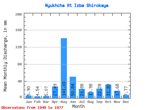
| Statistic | Jan | Feb | Mar | Apr | May | Jun | Jul | Aug | Sep | Oct | Nov | Dec | Annual |
|---|---|---|---|---|---|---|---|---|---|---|---|---|---|
| Mean | 5.90 | 4.58 | 5.07 | 27.49 | 141.01 | 50.84 | 21.87 | 13.98 | 22.28 | 31.82 | 17.68 | 7.77 | 347.35 |
| Standard Deviation | 1.77 | 1.44 | 1.67 | 32.64 | 48.83 | 27.65 | 14.28 | 10.31 | 16.18 | 22.88 | 11.74 | 2.82 | 67.40 |
| Min | 3.50 | 2.29 | 2.84 | 3.42 | 37.70 | 16.30 | 6.55 | 5.03 | 6.78 | 7.90 | 5.21 | 4.34 | 255.83 |
| Max | 11.61 | 9.73 | 11.97 | 119.61 | 258.23 | 103.10 | 55.06 | 48.47 | 65.74 | 107.12 | 49.81 | 15.62 | 560.64 |
| Coefficient of Variation | 0.30 | 0.32 | 0.33 | 1.19 | 0.35 | 0.54 | 0.65 | 0.74 | 0.73 | 0.72 | 0.66 | 0.36 | 0.19 |
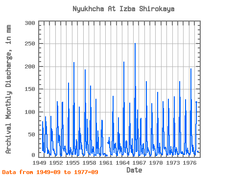
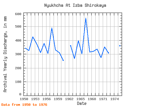
| Year | Jan | Feb | Mar | Apr | May | Jun | Jul | Aug | Sep | Oct | Nov | Dec | Annual | 1949 | 14.60 | 80.19 | 49.81 | 15.44 | 1950 | 11.61 | 9.73 | 11.97 | 88.91 | 69.42 | 67.48 | 34.11 | 7.84 | 9.24 | 16.64 | 8.86 | 7.96 | 344.22 | 1951 | 6.43 | 4.09 | 5.48 | 89.49 | 37.70 | 60.53 | 55.06 | 18.58 | 14.39 | 18.43 | 9.04 | 6.73 | 326.15 | 1952 | 6.37 | 4.69 | 4.10 | 5.82 | 126.27 | 103.10 | 32.32 | 40.39 | 48.37 | 44.58 | 5.21 | 5.03 | 424.36 | 1953 | 4.49 | 2.78 | 3.50 | 119.61 | 125.37 | 20.10 | 16.73 | 13.85 | 24.09 | 24.98 | 12.45 | 9.04 | 376.25 | 1954 | 6.94 | 5.34 | 5.75 | 11.70 | 168.76 | 50.39 | 8.98 | 5.42 | 7.88 | 21.27 | 13.41 | 6.73 | 310.19 | 1955 | 6.25 | 5.37 | 5.62 | 19.38 | 215.44 | 29.54 | 7.42 | 6.55 | 11.06 | 39.20 | 29.83 | 4.67 | 376.96 | 1956 | 3.65 | 3.63 | 3.77 | 4.95 | 114.00 | 17.67 | 53.86 | 48.47 | 18.16 | 26.90 | 7.53 | 5.69 | 304.67 | 1957 | 5.00 | 4.36 | 4.40 | 5.56 | 198.38 | 45.18 | 23.64 | 15.38 | 50.39 | 85.58 | 45.76 | 10.68 | 490.65 | 1958 | 8.68 | 6.95 | 7.45 | 4.98 | 162.18 | 62.56 | 11.82 | 8.29 | 12.22 | 23.88 | 19.75 | 4.34 | 331.03 | 1959 | 5.03 | 4.74 | 4.67 | 4.20 | 131.66 | 21.52 | 31.12 | 8.80 | 57.63 | 30.52 | 7.94 | 6.16 | 311.78 | 1960 | 4.94 | 3.87 | 4.73 | 38.81 | 83.78 | 78.77 | 8.50 | 5.03 | 7.01 | 7.90 | 7.09 | 5.33 | 255.83 | 1961 | 4.55 | 3.71 | 3.98 | 3.42 | 32.62 | 30.52 | 43.15 | 24.51 | 16.19 | 7.33 | 1962 | 6.13 | 5.10 | 5.39 | 66.32 | 137.94 | 16.54 | 20.89 | 10.47 | 28.30 | 24.03 | 30.70 | 9.04 | 359.47 | 1963 | 5.95 | 4.01 | 3.89 | 21.58 | 89.77 | 17.64 | 52.06 | 9.43 | 16.45 | 23.43 | 18.16 | 6.61 | 266.94 | 1964 | 5.75 | 4.44 | 4.73 | 7.47 | 216.03 | 30.12 | 12.60 | 10.14 | 33.02 | 37.70 | 31.86 | 7.72 | 398.14 | 1965 | 5.39 | 4.23 | 4.88 | 15.15 | 122.98 | 29.83 | 24.68 | 11.55 | 10.46 | 41.89 | 27.86 | 6.70 | 303.23 | 1966 | 4.58 | 2.70 | 3.14 | 9.30 | 258.23 | 61.69 | 12.51 | 12.60 | 65.74 | 107.12 | 21.20 | 6.58 | 560.64 | 1967 | 3.50 | 3.22 | 4.82 | 80.80 | 87.97 | 38.23 | 15.71 | 6.88 | 9.85 | 29.74 | 29.25 | 5.92 | 315.69 | 1968 | 4.34 | 3.87 | 4.64 | 4.66 | 171.15 | 58.79 | 10.32 | 21.42 | 14.68 | 15.47 | 7.73 | 5.18 | 319.65 | 1969 | 3.77 | 2.29 | 2.84 | 8.34 | 122.08 | 77.33 | 24.71 | 15.02 | 27.80 | 21.54 | 16.74 | 15.62 | 336.49 | 1970 | 3.65 | 3.71 | 4.10 | 6.29 | 146.92 | 28.24 | 12.96 | 6.94 | 10.86 | 31.72 | 13.90 | 7.78 | 274.37 | 1971 | 7.99 | 6.41 | 4.91 | 6.40 | 125.67 | 92.10 | 20.14 | 18.70 | 20.77 | 22.95 | 17.78 | 8.89 | 351.45 | 1972 | 6.04 | 4.39 | 4.76 | 7.30 | 131.66 | 86.88 | 10.44 | 6.01 | 6.78 | 24.42 | 10.46 | 12.12 | 309.72 | 1973 | 7.57 | 5.02 | 5.33 | 39.39 | 136.74 | 16.30 | 6.55 | 12.45 | 21.46 | 15.23 | 9.88 | 6.76 | 280.93 | 1974 | 7.18 | 5.07 | 5.95 | 8.78 | 171.15 | 98.18 | 11.49 | 7.87 | 7.91 | 13.29 | 8.54 | 6.70 | 350.30 | 1975 | 7.24 | 5.37 | 5.71 | 56.76 | 131.06 | 77.04 | 18.76 | 7.48 | 12.37 | 20.41 | 10.14 | 9.01 | 360.47 | 1976 | 6.43 | 4.69 | 5.71 | 9.85 | 200.48 | 59.95 | 35.31 | 13.05 | 25.86 | 17.53 | 8.08 | 7.90 | 391.59 | 1977 | 5.71 | 4.39 | 5.83 | 24.44 | 124.47 | 27.05 | 7.12 | 12.39 | 15.76 |
|---|
 Return to R-Arctic Net Home Page