|
|
|||||||||||||||||
| Point ID: 6987 | Downloads | Plots | Site Data | Code: 11199 |
|
|
|||||||||||||||||
| Download | |
|---|---|
| Site Descriptor Information | Site Time Series Data |
| Link to all available data | |
| View: | Time Series | All |
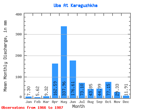
| Units: | m3/s |
| Statistic | Jan | Feb | Mar | Apr | May | Jun | Jul | Aug | Sep | Oct | Nov | Dec | Annual |
|---|---|---|---|---|---|---|---|---|---|---|---|---|---|
| Mean | 7.30 | 5.67 | 9.32 | 162.59 | 337.91 | 176.61 | 73.09 | 43.85 | 44.99 | 77.14 | 29.33 | 11.91 | 965.27 |
| Standard Deviation | 2.28 | 1.68 | 5.81 | 51.84 | 105.67 | 87.82 | 34.47 | 25.04 | 30.26 | 45.02 | 10.83 | 5.08 | 212.90 |
| Min | 4.16 | 3.51 | 5.11 | 79.70 | 162.35 | 56.05 | 20.34 | 13.89 | 15.07 | 17.07 | 12.31 | 3.44 | 629.39 |
| Max | 14.48 | 10.75 | 33.14 | 306.99 | 606.73 | 383.13 | 158.17 | 91.22 | 142.56 | 182.44 | 52.00 | 24.02 | 1432.09 |
| Coefficient of Variation | 0.31 | 0.30 | 0.62 | 0.32 | 0.31 | 0.50 | 0.47 | 0.57 | 0.67 | 0.58 | 0.37 | 0.43 | 0.22 |
 Return to R-Arctic Net Home Page