|
|
|||||||||||||||||
| Point ID: 6987 | Downloads | Plots | Site Data | Code: 11199 |
|
|
|||||||||||||||||
| Download | |
|---|---|
| Site Descriptor Information | Site Time Series Data |
| Link to all available data | |
|
|
| View: | Statistics | Time Series |
| Units: | m3/s |
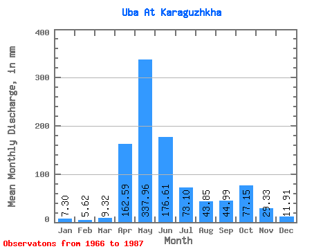
| Statistic | Jan | Feb | Mar | Apr | May | Jun | Jul | Aug | Sep | Oct | Nov | Dec | Annual |
|---|---|---|---|---|---|---|---|---|---|---|---|---|---|
| Mean | 7.30 | 5.67 | 9.32 | 162.59 | 337.91 | 176.61 | 73.09 | 43.85 | 44.99 | 77.14 | 29.33 | 11.91 | 965.27 |
| Standard Deviation | 2.28 | 1.68 | 5.81 | 51.84 | 105.67 | 87.82 | 34.47 | 25.04 | 30.26 | 45.02 | 10.83 | 5.08 | 212.90 |
| Min | 4.16 | 3.51 | 5.11 | 79.70 | 162.35 | 56.05 | 20.34 | 13.89 | 15.07 | 17.07 | 12.31 | 3.44 | 629.39 |
| Max | 14.48 | 10.75 | 33.14 | 306.99 | 606.73 | 383.13 | 158.17 | 91.22 | 142.56 | 182.44 | 52.00 | 24.02 | 1432.09 |
| Coefficient of Variation | 0.31 | 0.30 | 0.62 | 0.32 | 0.31 | 0.50 | 0.47 | 0.57 | 0.67 | 0.58 | 0.37 | 0.43 | 0.22 |
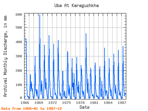
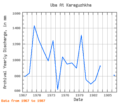
| Year | Jan | Feb | Mar | Apr | May | Jun | Jul | Aug | Sep | Oct | Nov | Dec | Annual | 1966 | 14.48 | 10.75 | 432.66 | 383.13 | 102.10 | 31.05 | 15.79 | 18.16 | 18.06 | 8.34 | 1967 | 5.67 | 5.28 | 12.30 | 173.34 | 162.35 | 56.05 | 126.37 | 91.22 | 56.13 | 77.16 | 20.98 | 7.78 | 790.89 | 1968 | 7.15 | 5.80 | 33.14 | 168.48 | 308.81 | 62.13 | 68.79 | 21.68 | 49.17 | 69.96 | 29.48 | 14.31 | 834.49 | 1969 | 7.67 | 5.46 | 7.99 | 179.82 | 606.73 | 256.77 | 74.06 | 35.23 | 73.06 | 132.23 | 48.84 | 11.30 | 1432.09 | 1970 | 9.46 | 8.08 | 10.63 | 158.76 | 389.98 | 231.66 | 69.46 | 85.36 | 142.56 | 87.03 | 42.61 | 20.00 | 1252.62 | 1971 | 11.21 | 5.12 | 7.46 | 161.19 | 459.44 | 255.15 | 87.87 | 58.58 | 22.92 | 17.07 | 18.47 | 10.13 | 1110.06 | 1972 | 8.34 | 6.23 | 6.60 | 145.80 | 395.84 | 174.15 | 102.94 | 31.55 | 46.90 | 34.48 | 28.19 | 13.22 | 989.88 | 1973 | 6.18 | 4.60 | 7.89 | 306.99 | 424.30 | 225.18 | 99.59 | 62.01 | 24.46 | 44.69 | 30.70 | 11.21 | 1245.02 | 1974 | 4.16 | 4.04 | 5.80 | 191.97 | 201.69 | 61.80 | 20.34 | 13.89 | 56.54 | 47.79 | 12.31 | 9.46 | 629.39 | 1975 | 8.03 | 7.16 | 9.04 | 102.87 | 343.96 | 315.09 | 55.07 | 24.69 | 42.85 | 97.08 | 27.46 | 8.33 | 1039.54 | 1976 | 7.06 | 5.61 | 5.95 | 153.09 | 292.07 | 87.48 | 114.65 | 18.58 | 55.48 | 182.44 | 28.19 | 6.29 | 950.85 | 1977 | 6.95 | 4.04 | 5.72 | 196.02 | 302.11 | 113.40 | 51.97 | 87.03 | 42.44 | 124.69 | 24.79 | 9.29 | 963.76 | 1978 | 5.03 | 4.74 | 8.96 | 235.71 | 200.85 | 207.36 | 49.04 | 52.05 | 17.82 | 58.92 | 38.56 | 19.83 | 899.49 | 1979 | 6.62 | 3.91 | 8.00 | 119.07 | 472.00 | 260.01 | 158.17 | 58.25 | 41.55 | 142.27 | 40.58 | 10.71 | 1312.86 | 1980 | 4.85 | 7.03 | 10.04 | 129.60 | 224.28 | 190.35 | 64.19 | 39.08 | 20.25 | 23.77 | 31.02 | 11.88 | 755.56 | 1981 | 8.62 | 7.23 | 12.30 | 220.32 | 261.94 | 78.81 | 33.14 | 18.75 | 15.07 | 24.52 | 12.55 | 7.71 | 699.74 | 1982 | 8.24 | 6.54 | 6.44 | 190.35 | 235.16 | 79.54 | 22.43 | 17.16 | 21.46 | 128.88 | 30.86 | 3.44 | 748.18 | 1983 | 5.78 | 4.67 | 7.99 | 105.30 | 368.23 | 177.39 | 47.70 | 23.68 | 60.18 | 60.76 | 52.00 | 12.97 | 923.37 | 1984 | 6.39 | 3.51 | 9.62 | 79.70 | 292.07 | 147.42 | 80.17 | 81.18 | 22.03 | 70.38 | 26.49 | 14.23 | 827.58 | 1985 | 6.79 | 3.95 | 5.11 | 158.76 | 325.54 | 204.93 | 71.47 | 55.40 | 38.48 | 98.75 | 32.80 | 19.50 | 1017.73 | 1986 | 5.26 | 5.27 | 7.36 | 113.40 | 352.32 | 159.57 | 35.90 | 29.88 | 26.57 | 53.90 | 14.98 | 8.14 | 808.74 | 1987 | 6.72 | 5.63 | 7.37 | 123.93 | 381.62 | 157.95 | 72.56 | 28.37 | 98.01 | 102.10 | 35.32 | 24.02 | 1038.94 |
|---|
 Return to R-Arctic Net Home Page